Ndélé geodata
Ndélé (Bamingui-Bangoran) is a seat of a first-order administrative division; located in Central African Republic in Africa/Bangui (GMT+1) time zone. With population of 11,764 people, there are 25 cities with bigger population in this country. Compared to other cities in Central African Republic, 97.1% of cities are located further ↓South; 62.9% of cities are located further ←West and 65.7% of cities have lower elevation than Ndélé. Note1


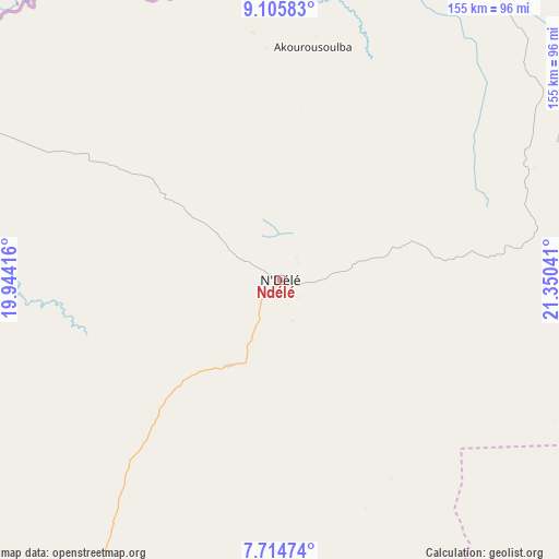
Ndélé GPS coordinates[2]
8° 24' 39.276" North, 20° 38' 50.208" East
| Map corner | latitude | longitude |
|---|---|---|
| Upper-left | 9.10583°, | 19.94416° |
| Center: | 8.41091°, | 20.64728° |
| Lower-right: | 7.71474°, | 21.35041° |
| Map W x H: | 154.7×154.7 km | = 96.1×96.1mi |
| max Lat: | 10.28488° ⇑2.9% North |
| Ndélé: | 8.41091° |
| min Lat: | ⇓97.1% South 3.52494° |
| min Long | Ndélé | max Long |
| 15.13926° | 20.64728° | 26.49211° |
| W 62.9%⇐ | ⇒37.1% E |
Elevation
Elevation of Ndélé is 514 m = 1686 ft, and this is 8.7 m = 29 ft above average elevation for this country.
| Max E: |
976 m = 3202 ft | 34.3% |
| Ndélé | 514 m 1686 ft | |
| Avg. | 505.3 m = 1658 ft | |
Min E: |
351 m = 1152 ft | 65.7% |
See also: Central African Republic elevation on elevation.city.
Geographical zone
Ndélé is located in North Torrid zone (between Equator and Tropic of Cancer). Distance of Equator is 935.2 km =581.1 mi to South.| Distance of | km | miles | from Ndélé |
|---|---|---|---|
| North Pole | 9071.9 | 5637 | to North |
| Arctic Circle | 6466 | 4017.8 | to North |
| Tropic Cancer | 1670.7 | 1038.1 | to North |
| Equator | 935.2 | 581.1 | to South |


Nearby cities:
15 places around Ndélé: (largest is in red/bold)
• Alindao
381.4 km =237 mi,  170°
170°
• Bambari
293.9 km =182.6 mi,  179°
179°
• Batangafo
288.2 km =179.1 mi,  244°
244°
• Birao
314 km =195.1 mi,  48°
48°
• Bossangoa
411.5 km =255.7 mi, 238°
• Bouca
336.3 km =209 mi,  230°
230°
• Bria
254.9 km =158.4 mi,  144°
144°
• Damara
439.6 km =273.2 mi,  209°
209°
• Ippy
246.6 km =153.2 mi, 165°
• Kabo
235.9 km =146.6 mi,  250°
250°
• Kaga Bandoro
225.5 km =140.1 mi, 225°
• Kembé
442.9 km =275.2 mi,  161°
161°
• Kouango
387.5 km =240.8 mi,  191°
191°
• Ouadda
196.5 km =122.1 mi,  100°
100°
• Sibut
346.1 km =215.1 mi, 210°
Sources, notices
• [Note1] Compared only with cities in Central African Republic existing in our database
• [Src1] Map data: © OpenStreetMap contributors (CC-BY-SA)
• [Src2] Other city data from geonames.org with taken over terms of usage.
• [Src3] Geographical zone / Annual Mean Temperature by Robert A. Rohde @ Wikipedia
