Bria geodata
Bria (Haute-Kotto) is a seat of a first-order administrative division; located in Central African Republic in Africa/Bangui (GMT+1) time zone. With population of 29,027 people, there are 9 cities with bigger population in this country. Compared to other cities in Central African Republic, 80% of cities are located further ↓South; 80% of cities are located further ←West and 71.4% of cities have lower elevation than Bria. Note1


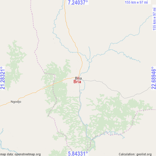
Bria GPS coordinates[2]
6° 32' 32.388" North, 21° 59' 10.788" East
| Map corner | latitude | longitude |
|---|---|---|
| Upper-left | 7.24037°, | 21.28321° |
| Center: | 6.54233°, | 21.98633° |
| Lower-right: | 5.84331°, | 22.68946° |
| Map W x H: | 155.3×155.3 km | = 96.5×96.5mi |
| max Lat: | 10.28488° ⇑20% North |
| Bria: | 6.54233° |
| min Lat: | ⇓80% South 3.52494° |
| min Long | Bria | max Long |
| 15.13926° | 21.98633° | 26.49211° |
| W 80%⇐ | ⇒20% E |
Elevation
Elevation of Bria is 572 m = 1877 ft, and this is 66.7 m = 219 ft above average elevation for this country.
| Max E: |
976 m = 3202 ft | 28.6% |
| Bria | 572 m 1877 ft | |
| Avg. | 505.3 m = 1658 ft | |
Min E: |
351 m = 1152 ft | 71.4% |
See also: Central African Republic elevation on elevation.city.
Geographical zone
Bria is located in North Torrid zone (between Equator and Tropic of Cancer). Distance of Equator is 727.4 km =452 mi to South.| Distance of | km | miles | from Bria |
|---|---|---|---|
| North Pole | 9279.6 | 5766.1 | to North |
| Arctic Circle | 6673.7 | 4146.8 | to North |
| Tropic Cancer | 1878.5 | 1167.2 | to North |
| Equator | 727.4 | 452 | to South |


Nearby cities:
15 places around Bria: (largest is in red/bold)
• Alindao
189.2 km =117.6 mi,  207°
207°
• Bambari
168.5 km =104.7 mi,  239°
239°
• Bangassou
220.4 km =137 mi,  155°
155°
• Gambo
212.8 km =132.2 mi,  171°
171°
• Ippy
89.5 km =55.6 mi,  250°
250°
• Kabo
392.1 km =243.6 mi,  289°
289°
• Kaga Bandoro
313 km =194.5 mi,  279°
279°
• Kembé
213.7 km =132.8 mi,  182°
182°
• Kouango
282.5 km =175.5 mi,  232°
232°
• Mobaye
262.9 km =163.4 mi,  199°
199°
• Ndélé
254.9 km =158.4 mi,  324°
324°
• Ouadda
176.7 km =109.8 mi,  14°
14°
• Ouango
255.7 km =158.9 mi, 165°
• Sibut
334.8 km =208 mi, 254°
• Zemio
386.8 km =240.3 mi,  115°
115°
Sources, notices
• [Note1] Compared only with cities in Central African Republic existing in our database
• [Src1] Map data: © OpenStreetMap contributors (CC-BY-SA)
• [Src2] Other city data from geonames.org with taken over terms of usage.
• [Src3] Geographical zone / Annual Mean Temperature by Robert A. Rohde @ Wikipedia
