Bétaré Oya geodata
Bétaré Oya (East) is a populated place; located in Cameroon in Africa/Douala (GMT+1) time zone. With population of 11,866 people, there are 67 cities with bigger population in this country. Compared to other cities in Cameroon, 64.8% of cities are located further ↓South; 86.1% of cities are located further ←West and 65.6% of cities have lower elevation than Bétaré Oya. Note1


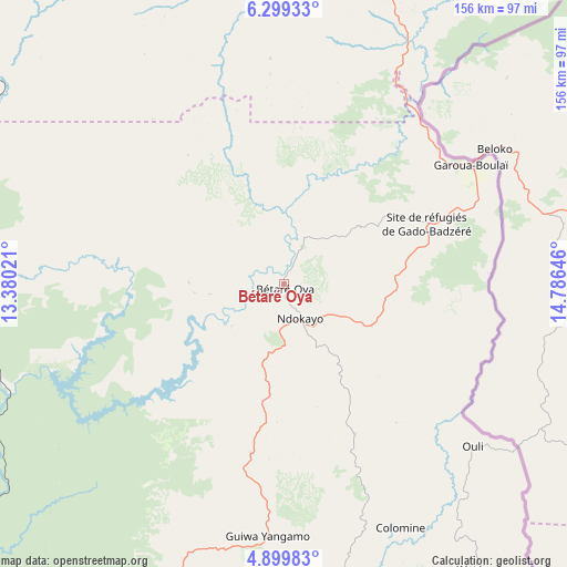
Bétaré Oya GPS coordinates[2]
5° 36' 0" North, 14° 4' 59.988" East
| Map corner | latitude | longitude |
|---|---|---|
| Upper-left | 6.29933°, | 13.38021° |
| Center: | 5.6°, | 14.08333° |
| Lower-right: | 4.89983°, | 14.78646° |
| Map W x H: | 155.6×155.6 km | = 96.7×96.7mi |
| max Lat: | 12.57535° ⇑35.2% North |
| Bétaré Oya: | 5.6° |
| min Lat: | ⇓64.8% South 2.35° |
| min Long | Bétaré Oya | max Long |
| 8.8724° | 14.08333° | 15.23288° |
| W 86.1%⇐ | ⇒13.9% E |
Elevation
Elevation of Bétaré Oya is 768 m = 2520 ft, and this is 94.1 m = 309 ft above average elevation for this country.
| Max E: |
1687 m = 5535 ft | 34.4% |
| Bétaré Oya | 768 m 2520 ft | |
| Avg. | 673.9 m = 2211 ft | |
Min E: |
1 m = 3 ft | 65.6% |
See also: Cameroon elevation on elevation.city.
Geographical zone
Bétaré Oya is located in North Torrid zone (between Equator and Tropic of Cancer). Distance of Equator is 622.7 km =386.9 mi to South.| Distance of | km | miles | from Bétaré Oya |
|---|---|---|---|
| North Pole | 9384.4 | 5831.2 | to North |
| Arctic Circle | 6778.5 | 4212 | to North |
| Tropic Cancer | 1983.3 | 1232.4 | to North |
| Equator | 622.7 | 386.9 | to South |


Nearby cities:
15 places around Bétaré Oya: (largest is in red/bold)
• Batouri
133.5 km =83 mi,  166°
166°
• Bertoua
122 km =75.8 mi,  201°
201°
• Bélabo
114.1 km =70.9 mi,  229°
229°
• Bélel
165.8 km =103 mi,  13°
13°
• Dimako
146.9 km =91.3 mi, 202°
• Djohong
153.1 km =95.1 mi,  26°
26°
• Doumé
167.4 km =104 mi, 204°
• Garoua Boulaï
60.5 km =37.6 mi,  58°
58°
• Mbang
140.3 km =87.2 mi,  216°
216°
• Meïganga
104.7 km =65.1 mi, 13°
• Minta
181.6 km =112.8 mi, 231°
• Ndelele
196.9 km =122.3 mi,  151°
151°
• Ngaoundéré
199.8 km =124.1 mi,  343°
343°
• Tibati
187.4 km =116.4 mi,  300°
300°
• Yoko
195.6 km =121.5 mi,  267°
267°
Sources, notices
• [Note1] Compared only with cities in Cameroon existing in our database
• [Src1] Map data: © OpenStreetMap contributors (CC-BY-SA)
• [Src2] Other city data from geonames.org with taken over terms of usage.
• [Src3] Geographical zone / Annual Mean Temperature by Robert A. Rohde @ Wikipedia
