Garoua Boulaï geodata
Garoua Boulaï (East) is a populated place; located in Cameroon in Africa/Douala (GMT+1) time zone. With population of 46,615 people, there are 37 cities with bigger population in this country. Compared to other cities in Cameroon, 68.9% of cities are located further ↓South; 95.1% of cities are located further ←West and 75.4% of cities have lower elevation than Garoua Boulaï. Note1


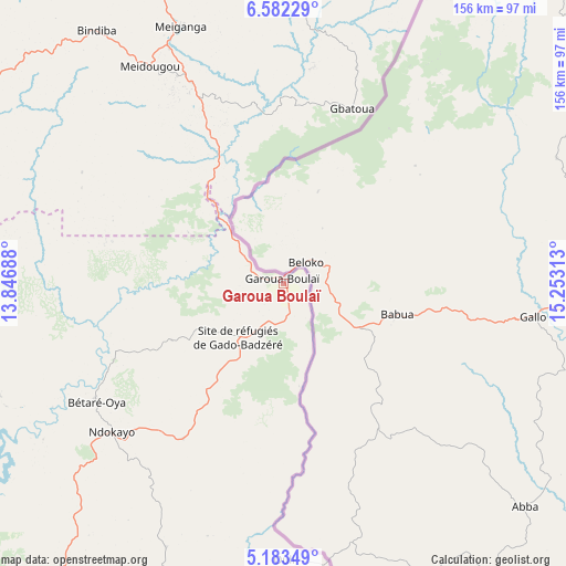
Garoua Boulaï GPS coordinates[2]
5° 52' 59.988" North, 14° 33' 0" East
| Map corner | latitude | longitude |
|---|---|---|
| Upper-left | 6.58229°, | 13.84688° |
| Center: | 5.88333°, | 14.55° |
| Lower-right: | 5.18349°, | 15.25313° |
| Map W x H: | 155.5×155.5 km | = 96.6×96.6mi |
| max Lat: | 12.57535° ⇑31.1% North |
| Garoua Boulaï: | 5.88333° |
| min Lat: | ⇓68.9% South 2.35° |
| min Long | Garoua Boulaï | max Long |
| 8.8724° | 14.55° | 15.23288° |
| W 95.1%⇐ | ⇒4.9% E |
Elevation
Elevation of Garoua Boulaï is 1034 m = 3392 ft, and this is 360.1 m = 1181 ft above average elevation for this country.
| Max E: |
1687 m = 5535 ft | 24.6% |
| Garoua Boulaï | 1034 m 3392 ft | |
| Avg. | 673.9 m = 2211 ft | |
Min E: |
1 m = 3 ft | 75.4% |
See also: Garoua Boulaï elevation on elevation.city.
Geographical zone
Garoua Boulaï is located in North Torrid zone (between Equator and Tropic of Cancer). Distance of Equator is 654.2 km =406.5 mi to South.| Distance of | km | miles | from Garoua Boulaï |
|---|---|---|---|
| North Pole | 9352.9 | 5811.6 | to North |
| Arctic Circle | 6747 | 4192.4 | to North |
| Tropic Cancer | 1951.8 | 1212.8 | to North |
| Equator | 654.2 | 406.5 | to South |


Nearby cities:
15 places around Garoua Boulaï: (largest is in red/bold)
• Batouri
162.5 km =101 mi,  187°
187°
• Bertoua
174 km =108.1 mi,  213°
213°
• Bélabo
174.1 km =108.2 mi,  232°
232°
• Bélel
130.4 km =81 mi,  354°
354°
• Bétaré Oya
60.5 km =37.6 mi,  238°
238°
• Dimako
199.2 km =123.8 mi, 213°
• Djohong
106.9 km =66.4 mi,  8°
8°
• Doumé
220.2 km =136.8 mi, 213°
• Mbang
197.6 km =122.8 mi,  222°
222°
• Meïganga
75.6 km =47 mi,  338°
338°
• Minta
241.7 km =150.2 mi, 233°
• Ndelele
209.1 km =129.9 mi,  168°
168°
• Ngaoundéré
192.8 km =119.8 mi,  326°
326°
• Tibati
222 km =137.9 mi,  286°
286°
• Yoko
250.1 km =155.4 mi,  261°
261°
Sources, notices
• [Note1] Compared only with cities in Cameroon existing in our database
• [Src1] Map data: © OpenStreetMap contributors (CC-BY-SA)
• [Src2] Other city data from geonames.org with taken over terms of usage.
• [Src3] Geographical zone / Annual Mean Temperature by Robert A. Rohde @ Wikipedia
