Racaka geodata
Racaka (Tibet) is a seat of a third-order administrative division; located in China in Asia/Shanghai (GMT+8) time zone. In our database, there are 1268 cities with bigger population. Compared to other cities in China, 57.7% of cities are located further ↓South; 95.8% of cities are located further →East and 100% of cities have lower elevation than Racaka. Note1


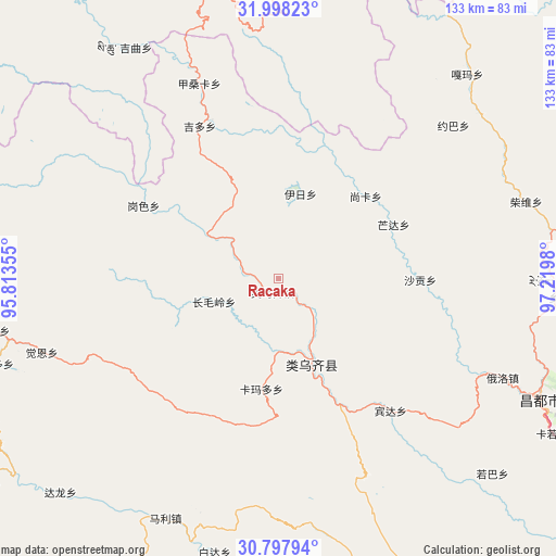
Racaka GPS coordinates[2]
31° 24' 0" North, 96° 31' 0.012" East
| Map corner | latitude | longitude |
|---|---|---|
| Upper-left | 31.99823°, | 95.81355° |
| Center: | 31.4°, | 96.51667° |
| Lower-right: | 30.79794°, | 97.2198° |
| Map W x H: | 133.5×133.5 km | = 83×83mi |
| max Lat: | 53.31946° ⇑42.3% North |
| Racaka: | 31.4° |
| min Lat: | ⇓57.7% South 18.22056° |
| min Long | Racaka | max Long |
| 75.07348° | 96.51667° | 134.28917° |
| W 4.2%⇐ | ⇒95.8% E |
Elevation
Elevation of Racaka is 5015 m = 16453 ft, and this is 4530.2 m = 14863 ft above average elevation for this country.
| Max E: |
5622 m = 18445 ft | 0% |
| Racaka | 5015 m 16453 ft | |
| Avg. | 484.8 m = 1591 ft | |
Min E: |
-3 m = -10 ft | 100% |
See also: China elevation on elevation.city.
Geographical zone
Racaka is located in North temperate zone (between Tropic of Cancer and the Arctic Circle). Distance of this Northern Tropic circle is 885.4 km =550.2 mi to South.| Distance of | km | miles | from Racaka |
|---|---|---|---|
| North Pole | 6515.7 | 4048.7 | to North |
| Arctic Circle | 3909.8 | 2429.4 | to North |
| Tropic Cancer | 885.4 | 550.2 | to South |
| Equator | 3491.4 | 2169.5 | to South |


Nearby cities:
15 places around Racaka: (largest is in red/bold)
• Dingqing
88.5 km =55 mi,  270°
270°
• Gaxung
110 km =68.4 mi,  312°
312°
• Gyamotang
103.8 km =64.5 mi,  278°
278°
• Jinisai
88.6 km =55.1 mi,  326°
326°
• Jiqu
71.9 km =44.7 mi, 328°
• Mozhong
100.9 km =62.7 mi,  16°
16°
• Nyagla
77.6 km =48.2 mi, 23°
• Qamdo
69.8 km =43.4 mi,  115°
115°
• Qiezha
75.1 km =46.7 mi,  359°
359°
• Samdo
22.1 km =13.7 mi,  159°
159°
• Xangda
89.6 km =55.7 mi, 357°
• Xiao Surmang
125.4 km =77.9 mi,  32°
32°
• Xiexiong
85.1 km =52.9 mi, 270°
• Yanduo
130.2 km =80.9 mi,  129°
129°
• Zito
98 km =60.9 mi,  221°
221°
Sources, notices
• [Note1] Compared only with cities in China existing in our database
• [Src1] Map data: © OpenStreetMap contributors (CC-BY-SA)
• [Src2] Other city data from geonames.org with taken over terms of usage.
• [Src3] Geographical zone / Annual Mean Temperature by Robert A. Rohde @ Wikipedia
