Coello geodata
Coello (Tolima) is a populated place; located in Colombia in America/Bogota (GMT-5) time zone. With population of 9,887 people, there are 310 cities with bigger population in this country. Compared to other cities in Colombia, 72.9% of cities are located further ↑North; 61.5% of cities are located further →East and 55.3% of cities have lower elevation than Coello. Note1


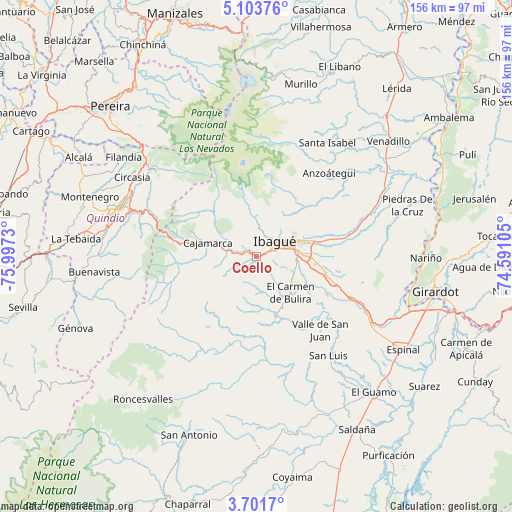
Coello GPS coordinates[2]
4° 24' 11.016" North, 75° 17' 39.012" West
| Map corner | latitude | longitude |
|---|---|---|
| Upper-left | 5.10376°, | -75.9973° |
| Center: | 4.40306°, | -75.29417° |
| Lower-right: | 3.7017°, | -74.59105° |
| Map W x H: | 155.9×155.9 km | = 96.9×96.9mi |
| max Lat: | 13.38166° ⇑72.9% North |
| Coello: | 4.40306° |
| min Lat: | ⇓27.1% South -4.21528° |
| min Long | Coello | max Long |
| -81.70636° | -75.29417° | -67.06996° |
| W 38.5%⇐ | ⇒61.5% E |
Elevation
Elevation of Coello is 1303 m = 4275 ft, and this is 153.7 m = 504 ft above average elevation for this country.
| Max E: |
3342 m = 10965 ft | 44.7% |
| Coello | 1303 m 4275 ft | |
| Avg. | 1149.3 m = 3771 ft | |
Min E: |
1 m = 3 ft | 55.3% |
See also: Colombia elevation on elevation.city.
Geographical zone
Coello is located in North Torrid zone (between Equator and Tropic of Cancer). Distance of Equator is 489.6 km =304.2 mi to South.| Distance of | km | miles | from Coello |
|---|---|---|---|
| North Pole | 9517.5 | 5913.9 | to North |
| Arctic Circle | 6911.6 | 4294.7 | to North |
| Tropic Cancer | 2116.3 | 1315 | to North |
| Equator | 489.6 | 304.2 | to South |


Nearby cities:
15 places around Coello: (largest is in red/bold)
• Anaime
16.7 km =10.4 mi,  267°
267°
• Anzoátegui
33.6 km =20.9 mi,  41°
41°
• Cajamarca
15.5 km =9.6 mi,  286°
286°
• Calarcá
40.9 km =25.4 mi, 290°
• Chicoral
40.4 km =25.1 mi,  121°
121°
• Doima
35.4 km =22 mi,  85°
85°
• Ibagué
7.9 km =4.9 mi,  59°
59°
• Laureles
16.3 km =10.1 mi,  191°
191°
• Payandé
24.8 km =15.4 mi, 118°
• Playarrica
40.6 km =25.2 mi,  198°
198°
• Rovira
19.2 km =11.9 mi,  161°
161°
• Salento
40.2 km =25 mi,  310°
310°
• San Luis
37.3 km =23.2 mi,  143°
143°
• Santa Isabel
40.9 km =25.4 mi,  32°
32°
• Valle de San Juan
30 km =18.6 mi, 139°
Sources, notices
• [Note1] Compared only with cities in Colombia existing in our database
• [Src1] Map data: © OpenStreetMap contributors (CC-BY-SA)
• [Src2] Other city data from geonames.org with taken over terms of usage.
• [Src3] Geographical zone / Annual Mean Temperature by Robert A. Rohde @ Wikipedia
