Debila geodata
Debila (El Oued) is a populated place; located in Algeria in Africa/Algiers (GMT+1) time zone. With population of 36,834 people, there are 140 cities with bigger population in this country. Compared to other cities in Algeria, 89.9% of cities are located further ↑North; 90.7% of cities are located further ←West and 86.8% of cities have higher elevation than Debila. Note1


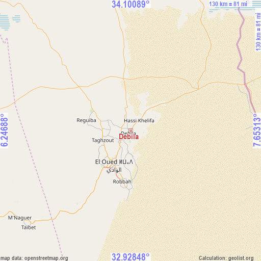
Debila GPS coordinates[2]
33° 31' 0.012" North, 6° 57' 0" East
| Map corner | latitude | longitude |
|---|---|---|
| Upper-left | 34.10089°, | 6.24688° |
| Center: | 33.51667°, | 6.95° |
| Lower-right: | 32.92848°, | 7.65313° |
| Map W x H: | 130.4×130.4 km | = 81×81mi |
| max Lat: | 36.92917° ⇑89.9% North |
| Debila: | 33.51667° |
| min Lat: | ⇓10.1% South 22.785° |
| min Long | Debila | max Long |
| -8.14743° | 6.95° | 8.46667° |
| W 90.7%⇐ | ⇒9.3% E |
Elevation
Elevation of Debila is 52 m = 171 ft, and this is 386.5 m = 1268 ft below average elevation for this country.
| Max E: |
1392 m = 4567 ft | 86.8% |
| Avg. | 438.5 m = 1439 ft | |
| Debila | 52 m = 171 ft | |
Min E: |
5 m = 16 ft | 13.2% |
See also: Algeria elevation on elevation.city.
Geographical zone
Debila is located in North temperate zone (between Tropic of Cancer and the Arctic Circle). Distance of this Northern Tropic circle is 1120.8 km =696.4 mi to South.| Distance of | km | miles | from Debila |
|---|---|---|---|
| North Pole | 6280.4 | 3902.5 | to North |
| Arctic Circle | 3674.5 | 2283.2 | to North |
| Tropic Cancer | 1120.8 | 696.4 | to South |
| Equator | 3726.7 | 2315.7 | to South |


Nearby cities:
15 places around Debila: (largest is in red/bold)
• Bir el Ater
170.6 km =106 mi,  36°
36°
• Biskra
186.1 km =115.6 mi,  322°
322°
• Djamaa
88.7 km =55.1 mi,  271°
271°
• El Hadjira
167.4 km =104 mi,  233°
233°
• El Oued
19.6 km =12.2 mi,  204°
204°
• Megarine
87.9 km =54.6 mi,  245°
245°
• Oumache
175.4 km =109 mi, 318°
• Reguiba
23.5 km =14.6 mi,  282°
282°
• Robbah
26.6 km =16.5 mi,  188°
188°
• Sidi Amrane
87.4 km =54.3 mi, 268°
• Sidi Okba
167.4 km =104 mi, 324°
• Tebesbest
92 km =57.2 mi,  241°
241°
• Tolga
197.2 km =122.5 mi,  312°
312°
• Touggourt
94.7 km =58.8 mi, 241°
• Zeribet el Oued
135.8 km =84.4 mi,  342°
342°
Sources, notices
• [Note1] Compared only with cities in Algeria existing in our database
• [Src1] Map data: © OpenStreetMap contributors (CC-BY-SA)
• [Src2] Other city data from geonames.org with taken over terms of usage.
• [Src3] Geographical zone / Annual Mean Temperature by Robert A. Rohde @ Wikipedia
