El Oued geodata
El Oued is a seat of a first-order administrative division; located in Algeria in Africa/Algiers (GMT+1) time zone. With population of 134,699 people, there are 26 cities with bigger population in this country. Compared to other cities in Algeria, 90.7% of cities are located further ↑North; 88.8% of cities are located further ←West and 80.6% of cities have higher elevation than El Oued. Note1


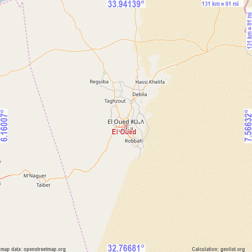
El Oued GPS coordinates[2]
33° 21' 21.888" North, 6° 51' 47.484" East
| Map corner | latitude | longitude |
|---|---|---|
| Upper-left | 33.94139°, | 6.16007° |
| Center: | 33.35608°, | 6.86319° |
| Lower-right: | 32.76681°, | 7.56632° |
| Map W x H: | 130.6×130.6 km | = 81.2×81.2mi |
| max Lat: | 36.92917° ⇑90.7% North |
| El Oued: | 33.35608° |
| min Lat: | ⇓9.3% South 22.785° |
| min Long | El Oued | max Long |
| -8.14743° | 6.86319° | 8.46667° |
| W 88.8%⇐ | ⇒11.2% E |
Elevation
Elevation of El Oued is 84 m = 276 ft, and this is 354.5 m = 1163 ft below average elevation for this country.
| Max E: |
1392 m = 4567 ft | 80.6% |
| Avg. | 438.5 m = 1439 ft | |
| El Oued | 84 m = 276 ft | |
Min E: |
5 m = 16 ft | 19.4% |
See also: El Oued elevation on elevation.city.
Geographical zone
El Oued is located in North temperate zone (between Tropic of Cancer and the Arctic Circle). Distance of this Northern Tropic circle is 1102.9 km =685.3 mi to South.| Distance of | km | miles | from El Oued |
|---|---|---|---|
| North Pole | 6298.2 | 3913.5 | to North |
| Arctic Circle | 3692.3 | 2294.3 | to North |
| Tropic Cancer | 1102.9 | 685.3 | to South |
| Equator | 3708.8 | 2304.5 | to South |


Nearby cities:
15 places around El Oued: (largest is in red/bold)
• Bir el Ater
189.8 km =117.9 mi,  35°
35°
• Biskra
196.3 km =122 mi,  327°
327°
• Debila
19.6 km =12.2 mi,  24°
24°
• Djamaa
83.1 km =51.6 mi,  283°
283°
• El Hadjira
150.6 km =93.6 mi,  236°
236°
• Hassi Messaoud
200.5 km =124.6 mi,  201°
201°
• Megarine
74.4 km =46.2 mi,  255°
255°
• Oumache
184.3 km =114.5 mi,  323°
323°
• Reguiba
27.5 km =17.1 mi, 327°
• Robbah
9.5 km =5.9 mi,  152°
152°
• Sidi Amrane
80.9 km =50.3 mi, 281°
• Sidi Okba
178.2 km =110.7 mi, 330°
• Tebesbest
77.3 km =48 mi,  249°
249°
• Touggourt
79.9 km =49.6 mi, 249°
• Zeribet el Oued
151 km =93.8 mi,  347°
347°
Sources, notices
• [Note1] Compared only with cities in Algeria existing in our database
• [Src1] Map data: © OpenStreetMap contributors (CC-BY-SA)
• [Src2] Other city data from geonames.org with taken over terms of usage.
• [Src3] Geographical zone / Annual Mean Temperature by Robert A. Rohde @ Wikipedia
