Megarine geodata
Megarine (Ouargla) is a populated place; located in Algeria in Africa/Algiers (GMT+1) time zone. With population of 31,711 people, there are 165 cities with bigger population in this country. Compared to other cities in Algeria, 91.9% of cities are located further ↑North; 81.8% of cities are located further ←West and 82.9% of cities have higher elevation than Megarine. Note1


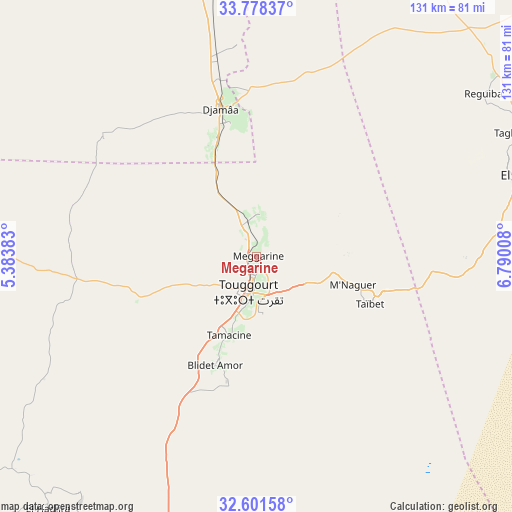
Megarine GPS coordinates[2]
33° 11' 31.02" North, 6° 5' 13.02" East
| Map corner | latitude | longitude |
|---|---|---|
| Upper-left | 33.77837°, | 5.38383° |
| Center: | 33.19195°, | 6.08695° |
| Lower-right: | 32.60158°, | 6.79008° |
| Map W x H: | 130.8×130.8 km | = 81.3×81.3mi |
| max Lat: | 36.92917° ⇑91.9% North |
| Megarine: | 33.19195° |
| min Lat: | ⇓8.1% South 22.785° |
| min Long | Megarine | max Long |
| -8.14743° | 6.08695° | 8.46667° |
| W 81.8%⇐ | ⇒18.2% E |
Elevation
Elevation of Megarine is 68 m = 223 ft, and this is 370.5 m = 1216 ft below average elevation for this country.
| Max E: |
1392 m = 4567 ft | 82.9% |
| Avg. | 438.5 m = 1439 ft | |
| Megarine | 68 m = 223 ft | |
Min E: |
5 m = 16 ft | 17.1% |
See also: Algeria elevation on elevation.city.
Geographical zone
Megarine is located in North temperate zone (between Tropic of Cancer and the Arctic Circle). Distance of this Northern Tropic circle is 1084.7 km =674 mi to South.| Distance of | km | miles | from Megarine |
|---|---|---|---|
| North Pole | 6316.5 | 3924.9 | to North |
| Arctic Circle | 3710.6 | 2305.7 | to North |
| Tropic Cancer | 1084.7 | 674 | to South |
| Equator | 3690.6 | 2293.2 | to South |


Nearby cities:
15 places around Megarine: (largest is in red/bold)
• Debila
87.9 km =54.6 mi,  65°
65°
• Djamaa
39 km =24.2 mi,  347°
347°
• El Hadjira
83.7 km =52 mi,  219°
219°
• El Oued
74.4 km =46.2 mi,  75°
75°
• Hassi Messaoud
168.1 km =104.5 mi,  180°
180°
• Ouargla
155.5 km =96.6 mi,  207°
207°
• Oumache
171 km =106.3 mi, 347°
• Reguiba
70.6 km =43.9 mi,  54°
54°
• Robbah
77.1 km =47.9 mi, 82°
• Rouissat
157 km =97.6 mi, 206°
• Sidi Amrane
34.9 km =21.7 mi, 347°
• Sidi Khaled
167.2 km =103.9 mi,  322°
322°
• Tebesbest
8.4 km =5.2 mi, 182°
• Touggourt
10 km =6.2 mi,  195°
195°
• Zeribet el Oued
170.3 km =105.8 mi,  13°
13°
Sources, notices
• [Note1] Compared only with cities in Algeria existing in our database
• [Src1] Map data: © OpenStreetMap contributors (CC-BY-SA)
• [Src2] Other city data from geonames.org with taken over terms of usage.
• [Src3] Geographical zone / Annual Mean Temperature by Robert A. Rohde @ Wikipedia
