Robbah geodata
Robbah (El Oued) is a populated place; located in Algeria in Africa/Algiers (GMT+1) time zone. With population of 30,446 people, there are 171 cities with bigger population in this country. Compared to other cities in Algeria, 91.1% of cities are located further ↑North; 89.9% of cities are located further ←West and 78.3% of cities have higher elevation than Robbah. Note1


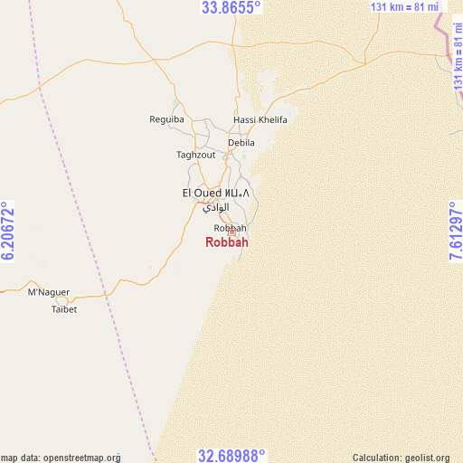
Robbah GPS coordinates[2]
33° 16' 46.812" North, 6° 54' 35.424" East
| Map corner | latitude | longitude |
|---|---|---|
| Upper-left | 33.8655°, | 6.20672° |
| Center: | 33.27967°, | 6.90984° |
| Lower-right: | 32.68988°, | 7.61297° |
| Map W x H: | 130.7×130.7 km | = 81.2×81.2mi |
| max Lat: | 36.92917° ⇑91.1% North |
| Robbah: | 33.27967° |
| min Lat: | ⇓8.9% South 22.785° |
| min Long | Robbah | max Long |
| -8.14743° | 6.90984° | 8.46667° |
| W 89.9%⇐ | ⇒10.1% E |
Elevation
Elevation of Robbah is 90 m = 295 ft, and this is 348.5 m = 1143 ft below average elevation for this country.
| Max E: |
1392 m = 4567 ft | 78.3% |
| Avg. | 438.5 m = 1439 ft | |
| Robbah | 90 m = 295 ft | |
Min E: |
5 m = 16 ft | 21.7% |
See also: Algeria elevation on elevation.city.
Geographical zone
Robbah is located in North temperate zone (between Tropic of Cancer and the Arctic Circle). Distance of this Northern Tropic circle is 1094.4 km =680 mi to South.| Distance of | km | miles | from Robbah |
|---|---|---|---|
| North Pole | 6306.7 | 3918.8 | to North |
| Arctic Circle | 3700.8 | 2299.6 | to North |
| Tropic Cancer | 1094.4 | 680 | to South |
| Equator | 3700.4 | 2299.3 | to South |


Nearby cities:
15 places around Robbah: (largest is in red/bold)
• Bir el Ater
194.4 km =120.8 mi,  33°
33°
• Biskra
205.8 km =127.9 mi,  328°
328°
• Debila
26.6 km =16.5 mi,  8°
8°
• Djamaa
89.7 km =55.7 mi,  288°
288°
• El Hadjira
150 km =93.2 mi,  240°
240°
• El Oued
9.5 km =5.9 mi, 332°
• Hassi Messaoud
194.4 km =120.8 mi,  203°
203°
• Megarine
77.1 km =47.9 mi,  262°
262°
• Oumache
193.7 km =120.4 mi,  324°
324°
• Reguiba
37 km =23 mi, 328°
• Sidi Amrane
87.2 km =54.2 mi, 286°
• Sidi Okba
187.7 km =116.6 mi, 330°
• Tebesbest
79 km =49.1 mi, 256°
• Touggourt
81.6 km =50.7 mi, 256°
• Zeribet el Oued
160.3 km =99.6 mi,  346°
346°
Sources, notices
• [Note1] Compared only with cities in Algeria existing in our database
• [Src1] Map data: © OpenStreetMap contributors (CC-BY-SA)
• [Src2] Other city data from geonames.org with taken over terms of usage.
• [Src3] Geographical zone / Annual Mean Temperature by Robert A. Rohde @ Wikipedia
