Djamaa geodata
Djamaa (Ouargla) is a populated place; located in Algeria in Africa/Algiers (GMT+1) time zone. With population of 52,882 people, there are 92 cities with bigger population in this country. Compared to other cities in Algeria, 89.5% of cities are located further ↑North; 79.5% of cities are located further ←West and 89.5% of cities have higher elevation than Djamaa. Note1


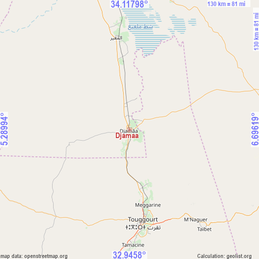
Djamaa GPS coordinates[2]
33° 32' 1.968" North, 5° 59' 35.016" East
| Map corner | latitude | longitude |
|---|---|---|
| Upper-left | 34.11798°, | 5.28994° |
| Center: | 33.53388°, | 5.99306° |
| Lower-right: | 32.9458°, | 6.69619° |
| Map W x H: | 130.3×130.3 km | = 81×81mi |
| max Lat: | 36.92917° ⇑89.5% North |
| Djamaa: | 33.53388° |
| min Lat: | ⇓10.5% South 22.785° |
| min Long | Djamaa | max Long |
| -8.14743° | 5.99306° | 8.46667° |
| W 79.5%⇐ | ⇒20.5% E |
Elevation
Elevation of Djamaa is 40 m = 131 ft, and this is 398.5 m = 1307 ft below average elevation for this country.
| Max E: |
1392 m = 4567 ft | 89.5% |
| Avg. | 438.5 m = 1439 ft | |
| Djamaa | 40 m = 131 ft | |
Min E: |
5 m = 16 ft | 10.5% |
See also: Djamaa elevation on elevation.city.
Geographical zone
Djamaa is located in North temperate zone (between Tropic of Cancer and the Arctic Circle). Distance of this Northern Tropic circle is 1122.7 km =697.6 mi to South.| Distance of | km | miles | from Djamaa |
|---|---|---|---|
| North Pole | 6278.4 | 3901.2 | to North |
| Arctic Circle | 3672.6 | 2282 | to North |
| Tropic Cancer | 1122.7 | 697.6 | to South |
| Equator | 3728.6 | 2316.8 | to South |


Nearby cities:
15 places around Djamaa: (largest is in red/bold)
• Biskra
148.4 km =92.2 mi,  350°
350°
• Debila
88.7 km =55.1 mi,  91°
91°
• El Hadjira
111.7 km =69.4 mi,  203°
203°
• El Oued
83.1 km =51.6 mi,  103°
103°
• Megarine
39 km =24.2 mi,  167°
167°
• Oumache
132 km =82 mi, 347°
• Reguiba
65.9 km =40.9 mi, 87°
• Robbah
89.7 km =55.7 mi,  108°
108°
• Sidi Amrane
4.1 km =2.5 mi,  160°
160°
• Sidi Khaled
132.6 km =82.4 mi,  315°
315°
• Sidi Okba
135 km =83.9 mi,  356°
356°
• Tebesbest
47.1 km =29.3 mi, 169°
• Tolga
143.7 km =89.3 mi,  336°
336°
• Touggourt
48 km =29.8 mi, 172°
• Zeribet el Oued
136.4 km =84.8 mi,  20°
20°
Sources, notices
• [Note1] Compared only with cities in Algeria existing in our database
• [Src1] Map data: © OpenStreetMap contributors (CC-BY-SA)
• [Src2] Other city data from geonames.org with taken over terms of usage.
• [Src3] Geographical zone / Annual Mean Temperature by Robert A. Rohde @ Wikipedia
