Oumache geodata
Oumache (Biskra) is a populated place; located in Algeria in Africa/Algiers (GMT+1) time zone. With population of 10,424 people, there are 249 cities with bigger population in this country. Compared to other cities in Algeria, 84.5% of cities are located further ↑North; 76.7% of cities are located further ←West and 85.7% of cities have higher elevation than Oumache. Note1


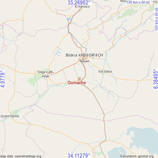
Oumache GPS coordinates[2]
34° 41' 34.512" North, 5° 40' 51.312" East
| Map corner | latitude | longitude |
|---|---|---|
| Upper-left | 35.26902°, | 4.9778° |
| Center: | 34.69292°, | 5.68092° |
| Lower-right: | 34.11279°, | 6.38405° |
| Map W x H: | 128.6×128.6 km | = 79.9×79.9mi |
| max Lat: | 36.92917° ⇑84.5% North |
| Oumache: | 34.69292° |
| min Lat: | ⇓15.5% South 22.785° |
| min Long | Oumache | max Long |
| -8.14743° | 5.68092° | 8.46667° |
| W 76.7%⇐ | ⇒23.3% E |
Elevation
Elevation of Oumache is 54 m = 177 ft, and this is 384.5 m = 1261 ft below average elevation for this country.
| Max E: |
1392 m = 4567 ft | 85.7% |
| Avg. | 438.5 m = 1439 ft | |
| Oumache | 54 m = 177 ft | |
Min E: |
5 m = 16 ft | 14.3% |
See also: Algeria elevation on elevation.city.
Geographical zone
Oumache is located in North temperate zone (between Tropic of Cancer and the Arctic Circle). Distance of this Northern Tropic circle is 1251.6 km =777.7 mi to South.| Distance of | km | miles | from Oumache |
|---|---|---|---|
| North Pole | 6149.6 | 3821.2 | to North |
| Arctic Circle | 3543.7 | 2202 | to North |
| Tropic Cancer | 1251.6 | 777.7 | to South |
| Equator | 3857.5 | 2396.9 | to South |


Nearby cities:
15 places around Oumache: (largest is in red/bold)
• Arris
87.4 km =54.3 mi,  43°
43°
• Aïn Touta
78.6 km =48.8 mi,  14°
14°
• Barika
82.5 km =51.3 mi,  339°
339°
• Batna
105.9 km =65.8 mi,  25°
25°
• Biskra
18 km =11.2 mi, 13°
• Boumagueur
91.1 km =56.6 mi,  352°
352°
• Djamaa
132 km =82 mi,  167°
167°
• Merouana
106.4 km =66.1 mi, 11°
• Râs el Aïoun
109.1 km =67.8 mi,  358°
358°
• Salah Bey
133.9 km =83.2 mi, 344°
• Sidi Khaled
72 km =44.7 mi,  241°
241°
• Sidi Okba
20.7 km =12.9 mi,  73°
73°
• Tazoult-Lambese
102.3 km =63.6 mi, 31°
• Tolga
27.8 km =17.3 mi,  276°
276°
• Zeribet el Oued
75.9 km =47.2 mi,  90°
90°
Sources, notices
• [Note1] Compared only with cities in Algeria existing in our database
• [Src1] Map data: © OpenStreetMap contributors (CC-BY-SA)
• [Src2] Other city data from geonames.org with taken over terms of usage.
• [Src3] Geographical zone / Annual Mean Temperature by Robert A. Rohde @ Wikipedia
