Brezina geodata
Brezina (El Bayadh) is a populated place; located in Algeria in Africa/Algiers (GMT+1) time zone. With population of 19,084 people, there are 236 cities with bigger population in this country. Compared to other cities in Algeria, 93% of cities are located further ↑North; 76.7% of cities are located further →East and 78.7% of cities have lower elevation than Brezina. Note1


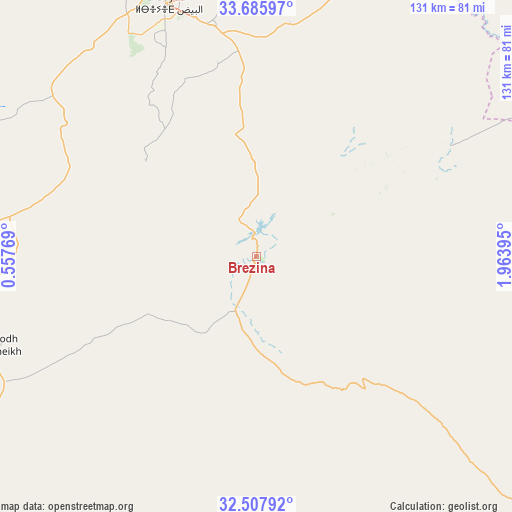
Brezina GPS coordinates[2]
33° 5' 56.112" North, 1° 15' 38.952" East
| Map corner | latitude | longitude |
|---|---|---|
| Upper-left | 33.68597°, | 0.55769° |
| Center: | 33.09892°, | 1.26082° |
| Lower-right: | 32.50792°, | 1.96395° |
| Map W x H: | 131×131 km | = 81.4×81.4mi |
| max Lat: | 36.92917° ⇑93% North |
| Brezina: | 33.09892° |
| min Lat: | ⇓7% South 22.785° |
| min Long | Brezina | max Long |
| -8.14743° | 1.26082° | 8.46667° |
| W 23.3%⇐ | ⇒76.7% E |
Elevation
Elevation of Brezina is 855 m = 2805 ft, and this is 416.5 m = 1366 ft above average elevation for this country.
| Max E: |
1392 m = 4567 ft | 21.3% |
| Brezina | 855 m 2805 ft | |
| Avg. | 438.5 m = 1439 ft | |
Min E: |
5 m = 16 ft | 78.7% |
See also: Algeria elevation on elevation.city.
Geographical zone
Brezina is located in North temperate zone (between Tropic of Cancer and the Arctic Circle). Distance of this Northern Tropic circle is 1074.3 km =667.5 mi to South.| Distance of | km | miles | from Brezina |
|---|---|---|---|
| North Pole | 6326.8 | 3931.3 | to North |
| Arctic Circle | 3720.9 | 2312.1 | to North |
| Tropic Cancer | 1074.3 | 667.5 | to South |
| Equator | 3680.3 | 2286.8 | to South |


Nearby cities:
15 places around Brezina: (largest is in red/bold)
• Aflou
137 km =85.1 mi,  34°
34°
• Aïn Sefra
176.4 km =109.6 mi,  257°
257°
• Charef
220.7 km =137.1 mi,  39°
39°
• Djebilet Rosfa
200.1 km =124.3 mi,  348°
348°
• El Abiodh Sidi Cheikh
70.3 km =43.7 mi,  250°
250°
• El Bayadh
68.7 km =42.7 mi,  340°
340°
• El Idrissia
190.1 km =118.1 mi, 38°
• Frenda
219.5 km =136.4 mi, 354°
• Laghouat
168 km =104.4 mi,  62°
62°
• Naama
148 km =92 mi,  277°
277°
• Saïda
218 km =135.5 mi,  332°
332°
• Sougueur
233 km =144.8 mi,  5°
5°
• ’Aïn Deheb
195.6 km =121.5 mi, 7°
• ’Aïn el Bell
228.4 km =141.9 mi,  52°
52°
• ’Aïn el Hadjar
211.3 km =131.3 mi, 330°
Sources, notices
• [Note1] Compared only with cities in Algeria existing in our database
• [Src1] Map data: © OpenStreetMap contributors (CC-BY-SA)
• [Src2] Other city data from geonames.org with taken over terms of usage.
• [Src3] Geographical zone / Annual Mean Temperature by Robert A. Rohde @ Wikipedia
