Cheria geodata
Cheria (Tébessa) is a populated place; located in Algeria in Africa/Algiers (GMT+1) time zone. With population of 72,095 people, there are 55 cities with bigger population in this country. Compared to other cities in Algeria, 73.6% of cities are located further ↑North; 95.7% of cities are located further ←West and 94.2% of cities have lower elevation than Cheria. Note1


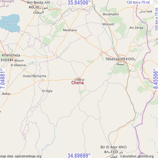
Cheria GPS coordinates[2]
35° 16' 23.016" North, 7° 45' 6.984" East
| Map corner | latitude | longitude |
|---|---|---|
| Upper-left | 35.84506°, | 7.04881° |
| Center: | 35.27306°, | 7.75194° |
| Lower-right: | 34.69699°, | 8.45506° |
| Map W x H: | 127.7×127.7 km | = 79.3×79.3mi |
| max Lat: | 36.92917° ⇑73.6% North |
| Cheria: | 35.27306° |
| min Lat: | ⇓26.4% South 22.785° |
| min Long | Cheria | max Long |
| -8.14743° | 7.75194° | 8.46667° |
| W 95.7%⇐ | ⇒4.3% E |
Elevation
Elevation of Cheria is 1094 m = 3589 ft, and this is 655.5 m = 2151 ft above average elevation for this country.
| Max E: |
1392 m = 4567 ft | 5.8% |
| Cheria | 1094 m 3589 ft | |
| Avg. | 438.5 m = 1439 ft | |
Min E: |
5 m = 16 ft | 94.2% |
See also: Cheria elevation on elevation.city.
Geographical zone
Cheria is located in North temperate zone (between Tropic of Cancer and the Arctic Circle). Distance of this Northern Tropic circle is 1316.1 km =817.8 mi to South.| Distance of | km | miles | from Cheria |
|---|---|---|---|
| North Pole | 6085.1 | 3781.1 | to North |
| Arctic Circle | 3479.2 | 2161.9 | to North |
| Tropic Cancer | 1316.1 | 817.8 | to South |
| Equator | 3922 | 2437 | to South |


Nearby cities:
15 places around Cheria: (largest is in red/bold)
• Arris
127.5 km =79.2 mi,  269°
269°
• Aïn Beïda
66.6 km =41.4 mi,  330°
330°
• Aïn Fakroun
111 km =69 mi,  314°
314°
• Aïn Kercha
119.9 km =74.5 mi, 307°
• Bir el Ater
65.1 km =40.5 mi,  154°
154°
• El Aouinet
67.1 km =41.7 mi,  10°
10°
• Hammamet
26.6 km =16.5 mi,  42°
42°
• Khenchela
58.1 km =36.1 mi,  288°
288°
• Meskiana
40.5 km =25.2 mi,  348°
348°
• Oum el Bouaghi
88.4 km =54.9 mi,  319°
319°
• Sedrata
97.2 km =60.4 mi, 348°
• Souk Ahras
114.1 km =70.9 mi, 9°
• Tébessa
36.8 km =22.9 mi,  66°
66°
• Zeribet el Oued
130.7 km =81.2 mi,  239°
239°
• ’Aïn Abid
129.2 km =80.3 mi, 325°
Sources, notices
• [Note1] Compared only with cities in Algeria existing in our database
• [Src1] Map data: © OpenStreetMap contributors (CC-BY-SA)
• [Src2] Other city data from geonames.org with taken over terms of usage.
• [Src3] Geographical zone / Annual Mean Temperature by Robert A. Rohde @ Wikipedia
