Tébessa geodata
Tébessa is a seat of a first-order administrative division; located in Algeria in Africa/Algiers (GMT+1) time zone. With population of 634,332 people, there are 3 cities with bigger population in this country. Compared to other cities in Algeria, 69.4% of cities are located further ↑North; 98.8% of cities are located further ←West and 80.2% of cities have lower elevation than Tébessa. Note1


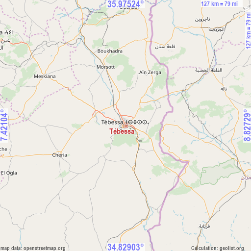
Tébessa GPS coordinates[2]
35° 24' 15.012" North, 8° 7' 27.012" East
| Map corner | latitude | longitude |
|---|---|---|
| Upper-left | 35.97524°, | 7.42104° |
| Center: | 35.40417°, | 8.12417° |
| Lower-right: | 34.82903°, | 8.82729° |
| Map W x H: | 127.4×127.4 km | = 79.2×79.2mi |
| max Lat: | 36.92917° ⇑69.4% North |
| Tébessa: | 35.40417° |
| min Lat: | ⇓30.6% South 22.785° |
| min Long | Tébessa | max Long |
| -8.14743° | 8.12417° | 8.46667° |
| W 98.8%⇐ | ⇒1.2% E |
Elevation
Elevation of Tébessa is 867 m = 2844 ft, and this is 428.5 m = 1406 ft above average elevation for this country.
| Max E: |
1392 m = 4567 ft | 19.8% |
| Tébessa | 867 m 2844 ft | |
| Avg. | 438.5 m = 1439 ft | |
Min E: |
5 m = 16 ft | 80.2% |
See also: Tébessa elevation on elevation.city.
Geographical zone
Tébessa is located in North temperate zone (between Tropic of Cancer and the Arctic Circle). Distance of this Northern Tropic circle is 1330.7 km =826.9 mi to South.| Distance of | km | miles | from Tébessa |
|---|---|---|---|
| North Pole | 6070.5 | 3772 | to North |
| Arctic Circle | 3464.6 | 2152.8 | to North |
| Tropic Cancer | 1330.7 | 826.9 | to South |
| Equator | 3936.6 | 2446.1 | to South |


Nearby cities:
15 places around Tébessa: (largest is in red/bold)
• Aïn Beïda
79.2 km =49.2 mi,  303°
303°
• Aïn Fakroun
129.3 km =80.3 mi, 299°
• Bir el Ater
73.5 km =45.7 mi,  184°
184°
• Boumahra Ahmed
129.4 km =80.4 mi,  334°
334°
• Cheria
36.8 km =22.9 mi,  246°
246°
• El Aouinet
55.7 km =34.6 mi,  337°
337°
• Guelma
133.4 km =82.9 mi, 331°
• Hammamet
16.4 km =10.2 mi,  287°
287°
• Héliopolis
136.8 km =85 mi, 333°
• Khenchela
88.9 km =55.2 mi,  272°
272°
• Meskiana
48.5 km =30.1 mi, 301°
• Oum el Bouaghi
105.3 km =65.4 mi, 299°
• Sedrata
96.6 km =60 mi, 326°
• Souk Ahras
99.3 km =61.7 mi,  350°
350°
• ’Aïn Abid
140.7 km =87.4 mi,  310°
310°
Sources, notices
• [Note1] Compared only with cities in Algeria existing in our database
• [Src1] Map data: © OpenStreetMap contributors (CC-BY-SA)
• [Src2] Other city data from geonames.org with taken over terms of usage.
• [Src3] Geographical zone / Annual Mean Temperature by Robert A. Rohde @ Wikipedia
