Hammamet geodata
Hammamet (Tébessa) is a populated place; located in Algeria in Africa/Algiers (GMT+1) time zone. With population of 28,536 people, there are 181 cities with bigger population in this country. Compared to other cities in Algeria, 68.2% of cities are located further ↑North; 98.1% of cities are located further ←West and 81% of cities have lower elevation than Hammamet. Note1


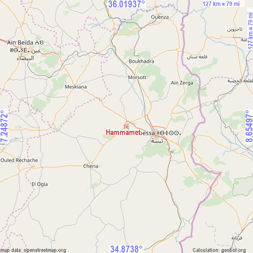
Hammamet GPS coordinates[2]
35° 26' 55.032" North, 7° 57' 6.624" East
| Map corner | latitude | longitude |
|---|---|---|
| Upper-left | 36.01937°, | 7.24872° |
| Center: | 35.44862°, | 7.95184° |
| Lower-right: | 34.8738°, | 8.65497° |
| Map W x H: | 127.4×127.4 km | = 79.2×79.2mi |
| max Lat: | 36.92917° ⇑68.2% North |
| Hammamet: | 35.44862° |
| min Lat: | ⇓31.8% South 22.785° |
| min Long | Hammamet | max Long |
| -8.14743° | 7.95184° | 8.46667° |
| W 98.1%⇐ | ⇒1.9% E |
Elevation
Elevation of Hammamet is 878 m = 2881 ft, and this is 439.5 m = 1442 ft above average elevation for this country.
| Max E: |
1392 m = 4567 ft | 19% |
| Hammamet | 878 m 2881 ft | |
| Avg. | 438.5 m = 1439 ft | |
Min E: |
5 m = 16 ft | 81% |
See also: Algeria elevation on elevation.city.
Geographical zone
Hammamet is located in North temperate zone (between Tropic of Cancer and the Arctic Circle). Distance of this Northern Tropic circle is 1335.6 km =829.9 mi to South.| Distance of | km | miles | from Hammamet |
|---|---|---|---|
| North Pole | 6065.5 | 3768.9 | to North |
| Arctic Circle | 3459.7 | 2149.8 | to North |
| Tropic Cancer | 1335.6 | 829.9 | to South |
| Equator | 3941.5 | 2449.1 | to South |


Nearby cities:
15 places around Hammamet: (largest is in red/bold)
• Aïn Beïda
63.6 km =39.5 mi,  307°
307°
• Aïn Fakroun
113.4 km =70.5 mi,  300°
300°
• Aïn Kercha
125.2 km =77.8 mi, 295°
• Bir el Ater
78.9 km =49 mi,  172°
172°
• Boumahra Ahmed
119 km =73.9 mi,  340°
340°
• Cheria
26.6 km =16.5 mi,  222°
222°
• El Aouinet
46.9 km =29.1 mi,  352°
352°
• Guelma
122.2 km =75.9 mi, 337°
• Khenchela
73.3 km =45.5 mi,  268°
268°
• Meskiana
32.8 km =20.4 mi, 308°
• Oum el Bouaghi
89.4 km =55.6 mi, 302°
• Sedrata
84.5 km =52.5 mi,  333°
333°
• Souk Ahras
93.2 km =57.9 mi,  359°
359°
• Tébessa
16.4 km =10.2 mi,  107°
107°
• ’Aïn Abid
125.9 km =78.2 mi, 313°
Sources, notices
• [Note1] Compared only with cities in Algeria existing in our database
• [Src1] Map data: © OpenStreetMap contributors (CC-BY-SA)
• [Src2] Other city data from geonames.org with taken over terms of usage.
• [Src3] Geographical zone / Annual Mean Temperature by Robert A. Rohde @ Wikipedia
