Râs el Aïoun geodata
Râs el Aïoun (Batna) is a populated place; located in Algeria in Africa/Algiers (GMT+1) time zone. With population of 34,167 people, there are 150 cities with bigger population in this country. Compared to other cities in Algeria, 62% of cities are located further ↑North; 76.4% of cities are located further ←West and 79.5% of cities have lower elevation than Râs el Aïoun. Note1


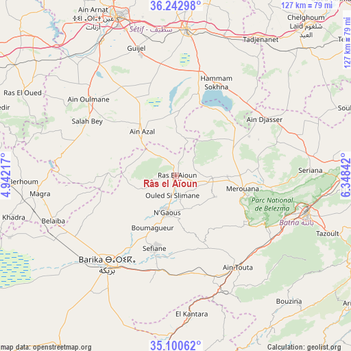
Râs el Aïoun GPS coordinates[2]
35° 40' 25.824" North, 5° 38' 43.08" East
| Map corner | latitude | longitude |
|---|---|---|
| Upper-left | 36.24298°, | 4.94217° |
| Center: | 35.67384°, | 5.6453° |
| Lower-right: | 35.10062°, | 6.34842° |
| Map W x H: | 127×127 km | = 78.9×78.9mi |
| max Lat: | 36.92917° ⇑62% North |
| Râs el Aïoun: | 35.67384° |
| min Lat: | ⇓38% South 22.785° |
| min Long | Râs el Aïoun | max Long |
| -8.14743° | 5.6453° | 8.46667° |
| W 76.4%⇐ | ⇒23.6% E |
Elevation
Elevation of Râs el Aïoun is 862 m = 2828 ft, and this is 423.5 m = 1389 ft above average elevation for this country.
| Max E: |
1392 m = 4567 ft | 20.5% |
| Râs el Aïoun | 862 m 2828 ft | |
| Avg. | 438.5 m = 1439 ft | |
Min E: |
5 m = 16 ft | 79.5% |
See also: Algeria elevation on elevation.city.
Geographical zone
Râs el Aïoun is located in North temperate zone (between Tropic of Cancer and the Arctic Circle). Distance of this Northern Tropic circle is 1360.6 km =845.4 mi to South.| Distance of | km | miles | from Râs el Aïoun |
|---|---|---|---|
| North Pole | 6040.5 | 3753.4 | to North |
| Arctic Circle | 3434.6 | 2134.2 | to North |
| Tropic Cancer | 1360.6 | 845.4 | to South |
| Equator | 3966.6 | 2464.7 | to South |


Nearby cities:
15 places around Râs el Aïoun: (largest is in red/bold)
• Arris
78.5 km =48.8 mi,  125°
125°
• Aïn Arnat
64.4 km =40 mi,  332°
332°
• Aïn Touta
40.3 km =25 mi,  145°
145°
• Barika
40.5 km =25.2 mi,  218°
218°
• Batna
49.6 km =30.8 mi,  105°
105°
• Bordj Ghdir
72 km =44.7 mi,  290°
290°
• Boumagueur
20.5 km =12.7 mi,  204°
204°
• Chelghoum el Aïd
71.8 km =44.6 mi,  40°
40°
• El Eulma
53.4 km =33.2 mi,  4°
4°
• Merouana
24.5 km =15.2 mi,  101°
101°
• Râs el Oued
63 km =39.1 mi,  298°
298°
• Salah Bey
37.8 km =23.5 mi, 302°
• Sétif
61.2 km =38 mi,  340°
340°
• Tazoult-Lambese
59.6 km =37 mi, 110°
• Telerghma
80.6 km =50.1 mi,  52°
52°
Sources, notices
• [Note1] Compared only with cities in Algeria existing in our database
• [Src1] Map data: © OpenStreetMap contributors (CC-BY-SA)
• [Src2] Other city data from geonames.org with taken over terms of usage.
• [Src3] Geographical zone / Annual Mean Temperature by Robert A. Rohde @ Wikipedia
