Boumagueur geodata
Boumagueur (Batna) is a populated place; located in Algeria in Africa/Algiers (GMT+1) time zone. With population of 8,474 people, there are 250 cities with bigger population in this country. Compared to other cities in Algeria, 66.7% of cities are located further ↑North; 76% of cities are located further ←West and 70.5% of cities have lower elevation than Boumagueur. Note1


Boumagueur GPS coordinates[2]
35° 30' 18.72" North, 5° 33' 9" East
| Map corner | latitude | longitude |
|---|---|---|
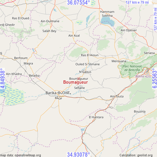
| Upper-left | 36.07554°, | 4.84938° |
| Center: | 35.5052°, | 5.5525° |
| Lower-right: | 34.93078°, | 6.25563° |
| Map W x H: | 127.3×127.3 km | = 79.1×79.1mi |
| max Lat: | 36.92917° ⇑66.7% North |
| Boumagueur: | 35.5052° |
| min Lat: | ⇓33.3% South 22.785° |
| min Long | Boumagueur | max Long |
| -8.14743° | 5.5525° | 8.46667° |
| W 76%⇐ | ⇒24% E |
Elevation
Elevation of Boumagueur is 678 m = 2224 ft, and this is 239.5 m = 786 ft above average elevation for this country.
| Max E: |
1392 m = 4567 ft | 29.5% |
| Boumagueur | 678 m 2224 ft | |
| Avg. | 438.5 m = 1439 ft | |
Min E: |
5 m = 16 ft | 70.5% |
See also: Algeria elevation on elevation.city.
Geographical zone
Boumagueur is located in North temperate zone (between Tropic of Cancer and the Arctic Circle). Distance of this Northern Tropic circle is 1341.9 km =833.8 mi to South.| Distance of | km | miles | from Boumagueur |
|---|---|---|---|
| North Pole | 6059.3 | 3765.1 | to North |
| Arctic Circle | 3453.4 | 2145.8 | to North |
| Tropic Cancer | 1341.9 | 833.8 | to South |
| Equator | 3947.8 | 2453 | to South |


Nearby cities:
15 places around Boumagueur: (largest is in red/bold)
• Arris
77.1 km =47.9 mi,  110°
110°
• Aïn Arnat
78.8 km =49 mi,  344°
344°
• Aïn Touta
34.6 km =21.5 mi, 114°
• Barika
21.3 km =13.2 mi,  232°
232°
• Batna
56.5 km =35.1 mi,  84°
84°
• Biskra
74.5 km =46.3 mi,  167°
167°
• Bordj Ghdir
73.7 km =45.8 mi,  306°
306°
• El Eulma
73.1 km =45.4 mi,  9°
9°
• Merouana
35.4 km =22 mi,  66°
66°
• Râs el Aïoun
20.5 km =12.7 mi,  24°
24°
• Râs el Oued
67.8 km =42.1 mi,  316°
316°
• Salah Bey
45.5 km =28.3 mi,  328°
328°
• Sétif
77.3 km =48 mi,  350°
350°
• Tazoult-Lambese
64.2 km =39.9 mi,  92°
92°
• Tolga
88.5 km =55 mi,  190°
190°
Sources, notices
• [Note1] Compared only with cities in Algeria existing in our database
• [Src1] Map data: © OpenStreetMap contributors (CC-BY-SA)
• [Src2] Other city data from geonames.org with taken over terms of usage.
• [Src3] Geographical zone / Annual Mean Temperature by Robert A. Rohde @ Wikipedia
