Messaad geodata
Messaad (Djelfa) is a populated place; located in Algeria in Africa/Algiers (GMT+1) time zone. With population of 99,485 people, there are 42 cities with bigger population in this country. Compared to other cities in Algeria, 87.6% of cities are located further ↑North; 50% of cities are located further ←West and 74.4% of cities have lower elevation than Messaad. Note1


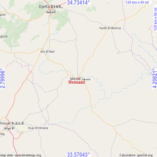
Messaad GPS coordinates[2]
34° 9' 15.444" North, 3° 30' 11.124" East
| Map corner | latitude | longitude |
|---|---|---|
| Upper-left | 34.73414°, | 2.79996° |
| Center: | 34.15429°, | 3.50309° |
| Lower-right: | 33.57043°, | 4.20621° |
| Map W x H: | 129.4×129.4 km | = 80.4×80.4mi |
| max Lat: | 36.92917° ⇑87.6% North |
| Messaad: | 34.15429° |
| min Lat: | ⇓12.4% South 22.785° |
| min Long | Messaad | max Long |
| -8.14743° | 3.50309° | 8.46667° |
| W 50%⇐ | ⇒50% E |
Elevation
Elevation of Messaad is 777 m = 2549 ft, and this is 338.5 m = 1111 ft above average elevation for this country.
| Max E: |
1392 m = 4567 ft | 25.6% |
| Messaad | 777 m 2549 ft | |
| Avg. | 438.5 m = 1439 ft | |
Min E: |
5 m = 16 ft | 74.4% |
See also: Messaad elevation on elevation.city.
Geographical zone
Messaad is located in North temperate zone (between Tropic of Cancer and the Arctic Circle). Distance of this Northern Tropic circle is 1191.7 km =740.5 mi to South.| Distance of | km | miles | from Messaad |
|---|---|---|---|
| North Pole | 6209.5 | 3858.4 | to North |
| Arctic Circle | 3603.6 | 2239.2 | to North |
| Tropic Cancer | 1191.7 | 740.5 | to South |
| Equator | 3797.6 | 2359.7 | to South |


Nearby cities:
15 places around Messaad: (largest is in red/bold)
• Aflou
129 km =80.2 mi,  267°
267°
• Aïn Oussera
154.2 km =95.8 mi,  339°
339°
• Berriane
149.7 km =93 mi,  170°
170°
• Birine
166.6 km =103.5 mi,  351°
351°
• Charef
83.1 km =51.6 mi,  308°
308°
• Dar Chioukh
82.5 km =51.3 mi,  358°
358°
• Djelfa
61.7 km =38.3 mi, 339°
• El Idrissia
95.3 km =59.2 mi,  289°
289°
• Ksar Chellala
159.9 km =99.4 mi,  317°
317°
• Laghouat
70.8 km =44 mi,  236°
236°
• Sidi Khaled
138.9 km =86.3 mi,  79°
79°
• Tolga
183.2 km =113.8 mi,  69°
69°
• ‘Aïn el Hadjel
172 km =106.9 mi,  11°
11°
• ’Aïn el Bell
33.1 km =20.6 mi, 309°
• ’Aïn el Melh
97.5 km =60.6 mi,  38°
38°
Sources, notices
• [Note1] Compared only with cities in Algeria existing in our database
• [Src1] Map data: © OpenStreetMap contributors (CC-BY-SA)
• [Src2] Other city data from geonames.org with taken over terms of usage.
• [Src3] Geographical zone / Annual Mean Temperature by Robert A. Rohde @ Wikipedia
