El Idrissia geodata
El Idrissia (Djelfa) is a populated place; located in Algeria in Africa/Algiers (GMT+1) time zone. With population of 38,714 people, there are 134 cities with bigger population in this country. Compared to other cities in Algeria, 86.4% of cities are located further ↑North; 68.6% of cities are located further →East and 92.6% of cities have lower elevation than El Idrissia. Note1


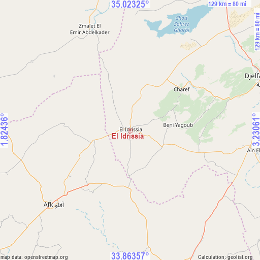
El Idrissia GPS coordinates[2]
34° 26' 43.512" North, 2° 31' 38.964" East
| Map corner | latitude | longitude |
|---|---|---|
| Upper-left | 35.02325°, | 1.82436° |
| Center: | 34.44542°, | 2.52749° |
| Lower-right: | 33.86357°, | 3.23061° |
| Map W x H: | 128.9×128.9 km | = 80.1×80.1mi |
| max Lat: | 36.92917° ⇑86.4% North |
| El Idrissia: | 34.44542° |
| min Lat: | ⇓13.6% South 22.785° |
| min Long | El Idrissia | max Long |
| -8.14743° | 2.52749° | 8.46667° |
| W 31.4%⇐ | ⇒68.6% E |
Elevation
Elevation of El Idrissia is 1070 m = 3510 ft, and this is 631.5 m = 2072 ft above average elevation for this country.
| Max E: |
1392 m = 4567 ft | 7.4% |
| El Idrissia | 1070 m 3510 ft | |
| Avg. | 438.5 m = 1439 ft | |
Min E: |
5 m = 16 ft | 92.6% |
See also: Algeria elevation on elevation.city.
Geographical zone
El Idrissia is located in North temperate zone (between Tropic of Cancer and the Arctic Circle). Distance of this Northern Tropic circle is 1224.1 km =760.6 mi to South.| Distance of | km | miles | from El Idrissia |
|---|---|---|---|
| North Pole | 6177.1 | 3838.3 | to North |
| Arctic Circle | 3571.2 | 2219 | to North |
| Tropic Cancer | 1224.1 | 760.6 | to South |
| Equator | 3830 | 2379.9 | to South |


Nearby cities:
15 places around El Idrissia: (largest is in red/bold)
• Aflou
53.8 km =33.4 mi,  226°
226°
• Aïn Oussera
117 km =72.7 mi,  17°
17°
• Birine
146.7 km =91.2 mi,  25°
25°
• Charef
31.3 km =19.4 mi,  51°
51°
• Dar Chioukh
100.9 km =62.7 mi,  60°
60°
• Djelfa
71.9 km =44.7 mi,  69°
69°
• Ksar Chellala
87.4 km =54.3 mi,  347°
347°
• Laghouat
78.2 km =48.6 mi,  156°
156°
• Mehdia daira de meghila
130.1 km =80.8 mi,  327°
327°
• Messaad
95.3 km =59.2 mi,  109°
109°
• Sougueur
125.1 km =77.7 mi,  311°
311°
• Tiaret
150.9 km =93.8 mi, 312°
• Tissemsilt
144.7 km =89.9 mi, 333°
• ’Aïn Deheb
100 km =62.1 mi,  296°
296°
• ’Aïn el Bell
65 km =40.4 mi,  100°
100°
Sources, notices
• [Note1] Compared only with cities in Algeria existing in our database
• [Src1] Map data: © OpenStreetMap contributors (CC-BY-SA)
• [Src2] Other city data from geonames.org with taken over terms of usage.
• [Src3] Geographical zone / Annual Mean Temperature by Robert A. Rohde @ Wikipedia
