’Aïn el Bell geodata
’Aïn el Bell (Djelfa) is a populated place; located in Algeria in Africa/Algiers (GMT+1) time zone. With population of 31,916 people, there are 162 cities with bigger population in this country. Compared to other cities in Algeria, 87.2% of cities are located further ↑North; 54.7% of cities are located further →East and 89.1% of cities have lower elevation than ’Aïn el Bell. Note1


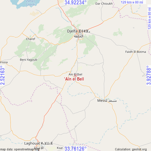
’Aïn el Bell GPS coordinates[2]
34° 20' 37.716" North, 3° 13' 29.1" East
| Map corner | latitude | longitude |
|---|---|---|
| Upper-left | 34.92234°, | 2.52163° |
| Center: | 34.34381°, | 3.22475° |
| Lower-right: | 33.76126°, | 3.92788° |
| Map W x H: | 129.1×129.1 km | = 80.2×80.2mi |
| max Lat: | 36.92917° ⇑87.2% North |
| ’Aïn el Bell: | 34.34381° |
| min Lat: | ⇓12.8% South 22.785° |
| min Long | ’Aïn el Bell | max Long |
| -8.14743° | 3.22475° | 8.46667° |
| W 45.3%⇐ | ⇒54.7% E |
Elevation
Elevation of ’Aïn el Bell is 1008 m = 3307 ft, and this is 569.5 m = 1868 ft above average elevation for this country.
| Max E: |
1392 m = 4567 ft | 10.9% |
| ’Aïn el Bell | 1008 m 3307 ft | |
| Avg. | 438.5 m = 1439 ft | |
Min E: |
5 m = 16 ft | 89.1% |
See also: Algeria elevation on elevation.city.
Geographical zone
’Aïn el Bell is located in North temperate zone (between Tropic of Cancer and the Arctic Circle). Distance of this Northern Tropic circle is 1212.8 km =753.6 mi to South.| Distance of | km | miles | from ’Aïn el Bell |
|---|---|---|---|
| North Pole | 6188.4 | 3845.3 | to North |
| Arctic Circle | 3582.5 | 2226.1 | to North |
| Tropic Cancer | 1212.8 | 753.6 | to South |
| Equator | 3818.7 | 2372.8 | to South |


Nearby cities:
15 places around ’Aïn el Bell: (largest is in red/bold)
• Aflou
106.3 km =66.1 mi,  256°
256°
• Aïn Oussera
126.5 km =78.6 mi,  346°
346°
• Birine
143.6 km =89.2 mi,  0°
0°
• Charef
50 km =31.1 mi,  308°
308°
• Dar Chioukh
65.9 km =40.9 mi,  21°
21°
• Djelfa
36.7 km =22.8 mi,  5°
5°
• El Idrissia
65 km =40.4 mi,  280°
280°
• Ksar Chellala
127.2 km =79 mi,  319°
319°
• Laghouat
68.9 km =42.8 mi,  208°
208°
• Messaad
33.1 km =20.6 mi,  129°
129°
• Sidi Khaled
161.9 km =100.6 mi,  88°
88°
• ‘Aïn el Hadjel
159.1 km =98.9 mi, 22°
• ’Aïn Boucif
172.2 km =107 mi,  357°
357°
• ’Aïn Deheb
163.3 km =101.5 mi,  289°
289°
• ’Aïn el Melh
102.2 km =63.5 mi,  57°
57°
Sources, notices
• [Note1] Compared only with cities in Algeria existing in our database
• [Src1] Map data: © OpenStreetMap contributors (CC-BY-SA)
• [Src2] Other city data from geonames.org with taken over terms of usage.
• [Src3] Geographical zone / Annual Mean Temperature by Robert A. Rohde @ Wikipedia
