Djelfa geodata
Djelfa is a seat of a first-order administrative division; located in Algeria in Africa/Algiers (GMT+1) time zone. With population of 154,265 people, there are 20 cities with bigger population in this country. Compared to other cities in Algeria, 85.3% of cities are located further ↑North; 53.9% of cities are located further →East and 97.3% of cities have lower elevation than Djelfa. Note1


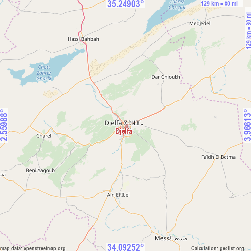
Djelfa GPS coordinates[2]
34° 40' 22.044" North, 3° 15' 46.8" East
| Map corner | latitude | longitude |
|---|---|---|
| Upper-left | 35.24903°, | 2.55988° |
| Center: | 34.67279°, | 3.263° |
| Lower-right: | 34.09252°, | 3.96613° |
| Map W x H: | 128.6×128.6 km | = 79.9×79.9mi |
| max Lat: | 36.92917° ⇑85.3% North |
| Djelfa: | 34.67279° |
| min Lat: | ⇓14.7% South 22.785° |
| min Long | Djelfa | max Long |
| -8.14743° | 3.263° | 8.46667° |
| W 46.1%⇐ | ⇒53.9% E |
Elevation
Elevation of Djelfa is 1138 m = 3734 ft, and this is 699.5 m = 2295 ft above average elevation for this country.
| Max E: |
1392 m = 4567 ft | 2.7% |
| Djelfa | 1138 m 3734 ft | |
| Avg. | 438.5 m = 1439 ft | |
Min E: |
5 m = 16 ft | 97.3% |
See also: Djelfa elevation on elevation.city.
Geographical zone
Djelfa is located in North temperate zone (between Tropic of Cancer and the Arctic Circle). Distance of this Northern Tropic circle is 1249.3 km =776.3 mi to South.| Distance of | km | miles | from Djelfa |
|---|---|---|---|
| North Pole | 6151.8 | 3822.6 | to North |
| Arctic Circle | 3545.9 | 2203.3 | to North |
| Tropic Cancer | 1249.3 | 776.3 | to South |
| Equator | 3855.3 | 2395.6 | to South |


Nearby cities:
15 places around Djelfa: (largest is in red/bold)
• Aflou
123.4 km =76.7 mi,  239°
239°
• Aïn Oussera
92.5 km =57.5 mi,  339°
339°
• Birine
107 km =66.5 mi,  358°
358°
• Charef
43.2 km =26.8 mi,  262°
262°
• Dar Chioukh
32.1 km =19.9 mi,  39°
39°
• El Idrissia
71.9 km =44.7 mi,  249°
249°
• Ksar Chellala
104.9 km =65.2 mi,  304°
304°
• Ksar el Boukhari
143 km =88.9 mi, 340°
• Laghouat
103.7 km =64.4 mi,  200°
200°
• Messaad
61.7 km =38.3 mi,  159°
159°
• Sidi Aïssa
142.5 km =88.5 mi,  18°
18°
• ‘Aïn el Hadjel
124.3 km =77.2 mi,  26°
26°
• ’Aïn Boucif
135.8 km =84.4 mi, 355°
• ’Aïn el Bell
36.7 km =22.8 mi,  185°
185°
• ’Aïn el Melh
84.4 km =52.4 mi,  77°
77°
Sources, notices
• [Note1] Compared only with cities in Algeria existing in our database
• [Src1] Map data: © OpenStreetMap contributors (CC-BY-SA)
• [Src2] Other city data from geonames.org with taken over terms of usage.
• [Src3] Geographical zone / Annual Mean Temperature by Robert A. Rohde @ Wikipedia
