Kawm Umbū geodata
Kawm Umbū (Aswan) is a populated place; located in Egypt in Africa/Cairo (GMT+2) time zone. With population of 59,787 people, there are 71 cities with bigger population in this country. Compared to other cities in Egypt, 98.6% of cities are located further ↑North; 87.7% of cities are located further ←West and 96.4% of cities have lower elevation than Kawm Umbū. Note1


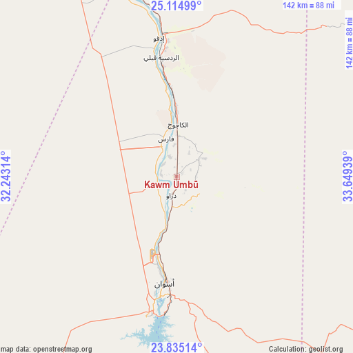
Kawm Umbū GPS coordinates[2]
24° 28' 36.084" North, 32° 56' 46.536" East
| Map corner | latitude | longitude |
|---|---|---|
| Upper-left | 25.11499°, | 32.24314° |
| Center: | 24.47669°, | 32.94626° |
| Lower-right: | 23.83514°, | 33.64939° |
| Map W x H: | 142.3×142.3 km | = 88.4×88.4mi |
| max Lat: | 31.5084° ⇑98.6% North |
| Kawm Umbū: | 24.47669° |
| min Lat: | ⇓1.4% South 22.3457° |
| min Long | Kawm Umbū | max Long |
| 25.51965° | 32.94626° | 34.89572° |
| W 87.7%⇐ | ⇒12.3% E |
Elevation
Elevation of Kawm Umbū is 108 m = 354 ft, and this is 64.5 m = 212 ft above average elevation for this country.
| Max E: |
1565 m = 5135 ft | 3.6% |
| Kawm Umbū | 108 m 354 ft | |
| Avg. | 43.5 m = 143 ft | |
Min E: |
-15 m = -49 ft | 96.4% |
See also: Kawm Umbū elevation on elevation.city.
Geographical zone
Kawm Umbū is located in North temperate zone (between Tropic of Cancer and the Arctic Circle). Distance of this Northern Tropic circle is 115.6 km =71.8 mi to South.| Distance of | km | miles | from Kawm Umbū |
|---|---|---|---|
| North Pole | 7285.5 | 4527 | to North |
| Arctic Circle | 4679.6 | 2907.8 | to North |
| Tropic Cancer | 115.6 | 71.8 | to South |
| Equator | 2721.6 | 1691.1 | to South |


Nearby cities:
15 places around Kawm Umbū: (largest is in red/bold)
• Akhmīm
261.3 km =162.4 mi,  332°
332°
• Al Balyanā
217.3 km =135 mi, 334°
• Al Manshāh
250.2 km =155.5 mi, 332°
• Al Quşayr
225.1 km =139.9 mi,  36°
36°
• Aswan
43.2 km =26.8 mi,  186°
186°
• Dishnā
189.2 km =117.6 mi,  345°
345°
• Farshūţ
192.3 km =119.5 mi,  335°
335°
• Idfū
56.3 km =35 mi, 352°
• Isnā
99 km =61.5 mi, 336°
• Jirjā
232.5 km =144.5 mi, 332°
• Kousa
161 km =100 mi, 353°
• Luxor
139.3 km =86.6 mi, 347°
• Marsa Alam
206.8 km =128.5 mi,  71°
71°
• Naja' Ḥammādī
188.7 km =117.3 mi, 337°
• Qinā
188.9 km =117.4 mi, 353°
In other languages:
- In Spanish: Kom Ombo
- In France: Kôm Ombo
- In German: Kom Ombo
- In Russian: Ком-Омбо
Sources, notices
• [Note1] Compared only with cities in Egypt existing in our database
• [Src1] Map data: © OpenStreetMap contributors (CC-BY-SA)
• [Src2] Other city data from geonames.org with taken over terms of usage.
• [Src3] Geographical zone / Annual Mean Temperature by Robert A. Rohde @ Wikipedia
