Luxor geodata
Luxor is a seat of a first-order administrative division; located in Egypt in Africa/Cairo (GMT+2) time zone. With population of 422,407 people, there are 6 cities with bigger population in this country. Compared to other cities in Egypt, 94.9% of cities are located further ↑North; 84.1% of cities are located further ←West and 94.2% of cities have lower elevation than Luxor. Note1


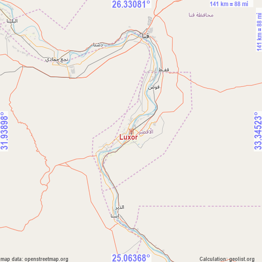
Luxor GPS coordinates[2]
25° 41' 56.148" North, 32° 38' 31.56" East
| Map corner | latitude | longitude |
|---|---|---|
| Upper-left | 26.33081°, | 31.93898° |
| Center: | 25.69893°, | 32.6421° |
| Lower-right: | 25.06368°, | 33.34523° |
| Map W x H: | 140.9×140.9 km | = 87.6×87.6mi |
| max Lat: | 31.5084° ⇑94.9% North |
| Luxor: | 25.69893° |
| min Lat: | ⇓5.1% South 22.3457° |
| min Long | Luxor | max Long |
| 25.51965° | 32.6421° | 34.89572° |
| W 84.1%⇐ | ⇒15.9% E |
Elevation
Elevation of Luxor is 89 m = 292 ft, and this is 45.5 m = 149 ft above average elevation for this country.
| Max E: |
1565 m = 5135 ft | 5.8% |
| Luxor | 89 m 292 ft | |
| Avg. | 43.5 m = 143 ft | |
Min E: |
-15 m = -49 ft | 94.2% |
See also: Luxor elevation on elevation.city.
Geographical zone
Luxor is located in North temperate zone (between Tropic of Cancer and the Arctic Circle). Distance of this Northern Tropic circle is 251.5 km =156.3 mi to South.| Distance of | km | miles | from Luxor |
|---|---|---|---|
| North Pole | 7149.6 | 4442.6 | to North |
| Arctic Circle | 4543.7 | 2823.3 | to North |
| Tropic Cancer | 251.5 | 156.3 | to South |
| Equator | 2857.5 | 1775.6 | to South |


Nearby cities:
15 places around Luxor: (largest is in red/bold)
• Akhmīm
131.3 km =81.6 mi,  316°
316°
• Al Balyanā
87.4 km =54.3 mi,  313°
313°
• Al Manshāh
120.4 km =74.8 mi, 315°
• Dishnā
50.2 km =31.2 mi,  340°
340°
• Farshūţ
62.1 km =38.6 mi, 309°
• Idfū
83.4 km =51.8 mi,  163°
163°
• Isnā
46 km =28.6 mi,  191°
191°
• Jirjā
103.3 km =64.2 mi, 313°
• Juhaynah
157.4 km =97.8 mi, 313°
• Kawm Umbū
139.3 km =86.6 mi,  167°
167°
• Kousa
26.9 km =16.7 mi,  26°
26°
• Naja' Ḥammādī
55.9 km =34.7 mi, 314°
• Qinā
52.4 km =32.6 mi,  9°
9°
• Sohag
134.3 km =83.5 mi, 315°
• Ţahţā
164.6 km =102.3 mi, 316°
Sources, notices
• [Note1] Compared only with cities in Egypt existing in our database
• [Src1] Map data: © OpenStreetMap contributors (CC-BY-SA)
• [Src2] Other city data from geonames.org with taken over terms of usage.
• [Src3] Geographical zone / Annual Mean Temperature by Robert A. Rohde @ Wikipedia
