Idfū geodata
Idfū (Aswan) is a populated place; located in Egypt in Africa/Cairo (GMT+2) time zone. With population of 133,000 people, there are 29 cities with bigger population in this country. Compared to other cities in Egypt, 97.8% of cities are located further ↑North; 86.2% of cities are located further ←West and 94.9% of cities have lower elevation than Idfū. Note1


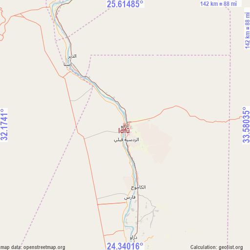
Idfū GPS coordinates[2]
24° 58' 44.976" North, 32° 52' 37.992" East
| Map corner | latitude | longitude |
|---|---|---|
| Upper-left | 25.61485°, | 32.1741° |
| Center: | 24.97916°, | 32.87722° |
| Lower-right: | 24.34016°, | 33.58035° |
| Map W x H: | 141.7×141.7 km | = 88×88mi |
| max Lat: | 31.5084° ⇑97.8% North |
| Idfū: | 24.97916° |
| min Lat: | ⇓2.2% South 22.3457° |
| min Long | Idfū | max Long |
| 25.51965° | 32.87722° | 34.89572° |
| W 86.2%⇐ | ⇒13.8% E |
Elevation
Elevation of Idfū is 90 m = 295 ft, and this is 46.5 m = 153 ft above average elevation for this country.
| Max E: |
1565 m = 5135 ft | 5.1% |
| Idfū | 90 m 295 ft | |
| Avg. | 43.5 m = 143 ft | |
Min E: |
-15 m = -49 ft | 94.9% |
See also: Idfū elevation on elevation.city.
Geographical zone
Idfū is located in North temperate zone (between Tropic of Cancer and the Arctic Circle). Distance of this Northern Tropic circle is 171.5 km =106.6 mi to South.| Distance of | km | miles | from Idfū |
|---|---|---|---|
| North Pole | 7229.6 | 4492.3 | to North |
| Arctic Circle | 4623.8 | 2873.1 | to North |
| Tropic Cancer | 171.5 | 106.6 | to South |
| Equator | 2777.4 | 1725.8 | to South |


Nearby cities:
15 places around Idfū: (largest is in red/bold)
• Akhmīm
209.4 km =130.1 mi,  327°
327°
• Al Balyanā
164.9 km =102.5 mi, 327°
• Al Manshāh
198.2 km =123.2 mi, 327°
• Al Quşayr
188.1 km =116.9 mi,  48°
48°
• Aswan
98.8 km =61.4 mi,  178°
178°
• Dishnā
133.6 km =83 mi,  342°
342°
• Farshūţ
139.4 km =86.6 mi, 329°
• Isnā
47.7 km =29.6 mi,  317°
317°
• Jirjā
180.5 km =112.2 mi, 326°
• Kawm Umbū
56.3 km =35 mi,  172°
172°
• Kousa
104.7 km =65.1 mi,  353°
353°
• Luxor
83.4 km =51.8 mi, 343°
• Marsa Alam
203 km =126.1 mi,  87°
87°
• Naja' Ḥammādī
135 km =83.9 mi, 331°
• Qinā
132.6 km =82.4 mi, 353°
In other languages:
- In Spanish: Edfu
- In France: Edfou
- In German: Edfu
- In Italian: Edfu
- In Russian: Эдфу
Sources, notices
• [Note1] Compared only with cities in Egypt existing in our database
• [Src1] Map data: © OpenStreetMap contributors (CC-BY-SA)
• [Src2] Other city data from geonames.org with taken over terms of usage.
• [Src3] Geographical zone / Annual Mean Temperature by Robert A. Rohde @ Wikipedia
