Dodola geodata
Dodola (Oromiya) is a populated place; located in Ethiopia in Africa/Addis_Ababa (GMT+3) time zone. With population of 23,116 people, there are 58 cities with bigger population in this country. Compared to other cities in Ethiopia, 81.3% of cities are located further ↑North; 68.2% of cities are located further ←West and 81.3% of cities have lower elevation than Dodola. Note1


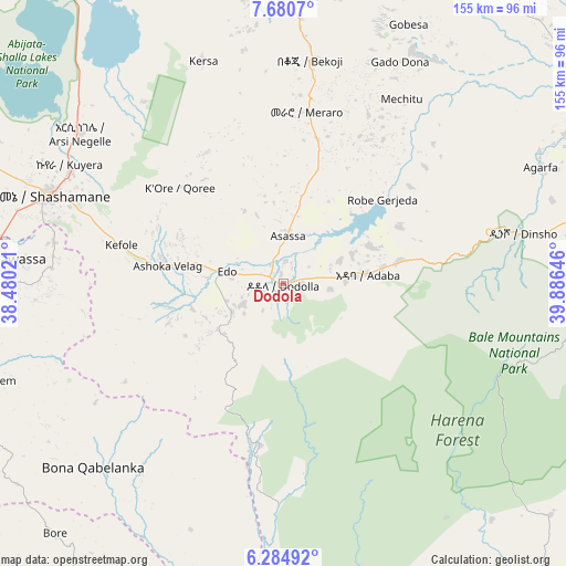
Dodola GPS coordinates[2]
6° 58' 59.988" North, 39° 10' 59.988" East
| Map corner | latitude | longitude |
|---|---|---|
| Upper-left | 7.6807°, | 38.48021° |
| Center: | 6.98333°, | 39.18333° |
| Lower-right: | 6.28492°, | 39.88646° |
| Map W x H: | 155.2×155.2 km | = 96.4×96.4mi |
| max Lat: | 14.277° ⇑81.3% North |
| Dodola: | 6.98333° |
| min Lat: | ⇓18.7% South 4.05° |
| min Long | Dodola | max Long |
| 34.53333° | 39.18333° | 42.8° |
| W 68.2%⇐ | ⇒31.8% E |
Elevation
Elevation of Dodola is 2464 m = 8084 ft, and this is 568.4 m = 1865 ft above average elevation for this country.
| Max E: |
2854 m = 9364 ft | 18.7% |
| Dodola | 2464 m 8084 ft | |
| Avg. | 1895.6 m = 6219 ft | |
Min E: |
367 m = 1204 ft | 81.3% |
See also: Ethiopia elevation on elevation.city.
Geographical zone
Dodola is located in North Torrid zone (between Equator and Tropic of Cancer). Distance of Equator is 776.5 km =482.5 mi to South.| Distance of | km | miles | from Dodola |
|---|---|---|---|
| North Pole | 9230.6 | 5735.6 | to North |
| Arctic Circle | 6624.7 | 4116.4 | to North |
| Tropic Cancer | 1829.4 | 1136.7 | to North |
| Equator | 776.5 | 482.5 | to South |


Nearby cities:
15 places around Dodola: (largest is in red/bold)
• Dīla
114.6 km =71.2 mi,  236°
236°
• Goba
88.4 km =54.9 mi,  87°
87°
• Hawassa
78.5 km =48.8 mi,  276°
276°
• Huruta
131 km =81.4 mi,  8°
8°
• Hāgere Selam
92.2 km =57.3 mi,  232°
232°
• Kibre Mengist
124.3 km =77.2 mi,  190°
190°
• Kofelē
45.1 km =28 mi, 281°
• K’olīto
126.9 km =78.9 mi,  286°
286°
• Leku
82.5 km =51.3 mi,  261°
261°
• Shakiso
138.8 km =86.2 mi, 192°
• Shashemenē
68.7 km =42.7 mi, 290°
• Wendo
94.8 km =58.9 mi, 243°
• Yirga ‘Alem
88.5 km =55 mi,  252°
252°
• Ziway
117.5 km =73 mi,  334°
334°
• Āsasa
13.1 km =8.1 mi, 8°
Sources, notices
• [Note1] Compared only with cities in Ethiopia existing in our database
• [Src1] Map data: © OpenStreetMap contributors (CC-BY-SA)
• [Src2] Other city data from geonames.org with taken over terms of usage.
• [Src3] Geographical zone / Annual Mean Temperature by Robert A. Rohde @ Wikipedia
