Gambēla geodata
Gambēla (Gambela) is a seat of a first-order administrative division; located in Ethiopia in Africa/Addis_Ababa (GMT+3) time zone. With population of 42,366 people, there are 24 cities with bigger population in this country. Compared to other cities in Ethiopia, 63.6% of cities are located further ↑North; 99.1% of cities are located further →East and 96.3% of cities have higher elevation than Gambēla. Note1


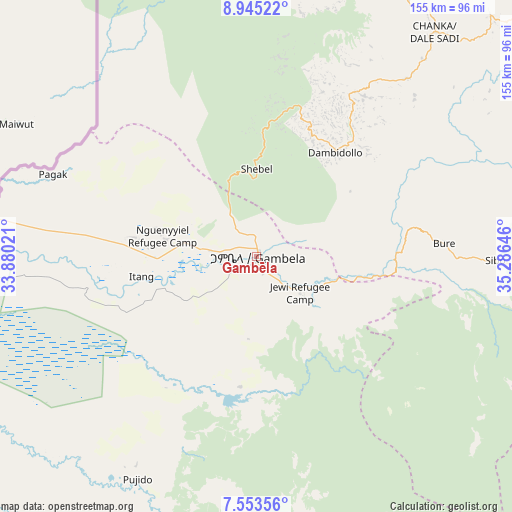
Gambēla GPS coordinates[2]
8° 15' 0" North, 34° 34' 59.988" East
| Map corner | latitude | longitude |
|---|---|---|
| Upper-left | 8.94522°, | 33.88021° |
| Center: | 8.25°, | 34.58333° |
| Lower-right: | 7.55356°, | 35.28646° |
| Map W x H: | 154.7×154.7 km | = 96.1×96.1mi |
| max Lat: | 14.277° ⇑63.6% North |
| Gambēla: | 8.25° |
| min Lat: | ⇓36.4% South 4.05° |
| min Long | Gambēla | max Long |
| 34.53333° | 34.58333° | 42.8° |
| W 0.9%⇐ | ⇒99.1% E |
Elevation
Elevation of Gambēla is 439 m = 1440 ft, and this is 1456.6 m = 4779 ft below average elevation for this country.
| Max E: |
2854 m = 9364 ft | 96.3% |
| Avg. | 1895.6 m = 6219 ft | |
| Gambēla | 439 m = 1440 ft | |
Min E: |
367 m = 1204 ft | 3.7% |
See also: Gambēla elevation on elevation.city.
Geographical zone
Gambēla is located in North Torrid zone (between Equator and Tropic of Cancer). Distance of Equator is 917.3 km =570 mi to South.| Distance of | km | miles | from Gambēla |
|---|---|---|---|
| North Pole | 9089.7 | 5648.1 | to North |
| Arctic Circle | 6483.9 | 4028.9 | to North |
| Tropic Cancer | 1688.6 | 1049.2 | to North |
| Equator | 917.3 | 570 | to South |


Nearby cities:
15 places around Gambēla: (largest is in red/bold)
• Bedelē
196 km =121.8 mi,  83°
83°
• Bonga
211.2 km =131.2 mi,  120°
120°
• Dembī Dolo
39.5 km =24.5 mi,  37°
37°
• Gimbi
171.4 km =106.5 mi,  53°
53°
• Gorē
105.1 km =65.3 mi,  96°
96°
• Gēdo
326.5 km =202.9 mi,  74°
74°
• Jimma
256 km =159.1 mi, 104°
• Mendī
181.4 km =112.7 mi,  18°
18°
• Metu
110.2 km =68.5 mi,  87°
87°
• Mīzan Teferī
177.9 km =110.5 mi,  141°
141°
• Nejo
171.6 km =106.6 mi, 35°
• Shambu
312.8 km =194.4 mi,  62°
62°
• Tippi
150.8 km =93.7 mi, 140°
• Āgaro
231.8 km =144 mi, 101°
• Āsosa
202.1 km =125.6 mi,  358°
358°
Sources, notices
• [Note1] Compared only with cities in Ethiopia existing in our database
• [Src1] Map data: © OpenStreetMap contributors (CC-BY-SA)
• [Src2] Other city data from geonames.org with taken over terms of usage.
• [Src3] Geographical zone / Annual Mean Temperature by Robert A. Rohde @ Wikipedia
