Āsosa geodata
Āsosa (Bīnshangul Gumuz) is a seat of a first-order administrative division; located in Ethiopia in Africa/Addis_Ababa (GMT+3) time zone. With population of 30,512 people, there are 39 cities with bigger population in this country. Compared to other cities in Ethiopia, 71% of cities are located further ↓South; 100% of cities are located further →East and 82.2% of cities have higher elevation than Āsosa. Note1


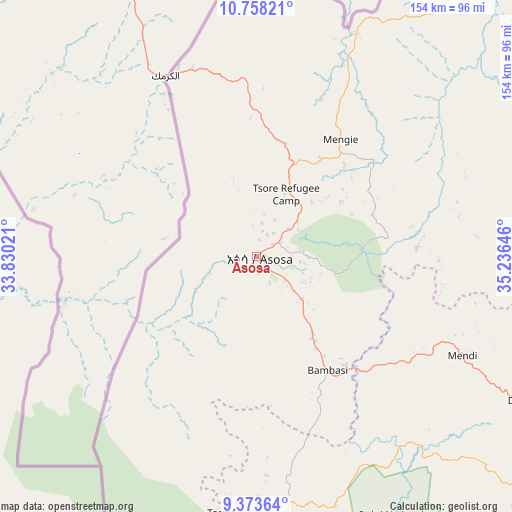
Āsosa GPS coordinates[2]
10° 4' 0.012" North, 34° 31' 59.988" East
| Map corner | latitude | longitude |
|---|---|---|
| Upper-left | 10.75821°, | 33.83021° |
| Center: | 10.06667°, | 34.53333° |
| Lower-right: | 9.37364°, | 35.23646° |
| Map W x H: | 153.9×154 km | = 95.6×95.7mi |
| max Lat: | 14.277° ⇑29% North |
| Āsosa: | 10.06667° |
| min Lat: | ⇓71% South 4.05° |
| min Long | Āsosa | max Long |
| 34.53333° | 34.53333° | 42.8° |
| W 0%⇐ | ⇒100% E |
Elevation
Elevation of Āsosa is 1530 m = 5020 ft, and this is 365.6 m = 1199 ft below average elevation for this country.
| Max E: |
2854 m = 9364 ft | 82.2% |
| Avg. | 1895.6 m = 6219 ft | |
| Āsosa | 1530 m = 5020 ft | |
Min E: |
367 m = 1204 ft | 17.8% |
See also: Ethiopia elevation on elevation.city.
Geographical zone
Āsosa is located in North Torrid zone (between Equator and Tropic of Cancer). Distance of Equator is 1119.3 km =695.5 mi to South.| Distance of | km | miles | from Āsosa |
|---|---|---|---|
| North Pole | 8887.8 | 5522.6 | to North |
| Arctic Circle | 6281.9 | 3903.4 | to North |
| Tropic Cancer | 1486.6 | 923.7 | to North |
| Equator | 1119.3 | 695.5 | to South |


Nearby cities:
15 places around Āsosa: (largest is in red/bold)
• Addiet Canna
348.9 km =216.8 mi,  67°
67°
• Bedelē
268.2 km =166.7 mi,  131°
131°
• Burē
285.9 km =177.7 mi,  75°
75°
• Dembī Dolo
173 km =107.5 mi,  170°
170°
• Finote Selam
307.1 km =190.8 mi, 76°
• Gambēla
202.1 km =125.6 mi,  178°
178°
• Gimbi
174 km =108.1 mi,  124°
124°
• Gorē
239.7 km =148.9 mi,  152°
152°
• Gēdo
340.5 km =211.6 mi,  110°
110°
• Mendī
68.8 km =42.8 mi, 115°
• Metu
227.7 km =141.5 mi, 149°
• Nejo
123.2 km =76.6 mi, 120°
• Shambu
286.6 km =178.1 mi,  101°
101°
• Tippi
334.3 km =207.7 mi,  162°
162°
• Āgaro
338.8 km =210.5 mi,  136°
136°
Sources, notices
• [Note1] Compared only with cities in Ethiopia existing in our database
• [Src1] Map data: © OpenStreetMap contributors (CC-BY-SA)
• [Src2] Other city data from geonames.org with taken over terms of usage.
• [Src3] Geographical zone / Annual Mean Temperature by Robert A. Rohde @ Wikipedia
