Burē geodata
Burē (Amhara) is a populated place; located in Ethiopia in Africa/Addis_Ababa (GMT+3) time zone. With population of 22,038 people, there are 62 cities with bigger population in this country. Compared to other cities in Ethiopia, 77.6% of cities are located further ↓South; 82.2% of cities are located further →East and 63.6% of cities have lower elevation than Burē. Note1


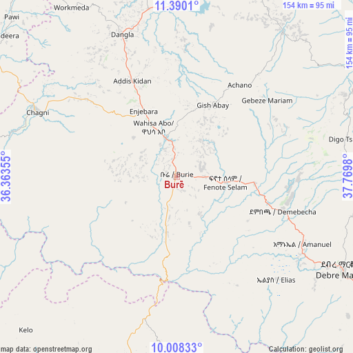
Burē GPS coordinates[2]
10° 42' 0" North, 37° 4' 0.012" East
| Map corner | latitude | longitude |
|---|---|---|
| Upper-left | 11.3901°, | 36.36355° |
| Center: | 10.7°, | 37.06667° |
| Lower-right: | 10.00833°, | 37.7698° |
| Map W x H: | 153.6×153.6 km | = 95.4×95.4mi |
| max Lat: | 14.277° ⇑22.4% North |
| Burē: | 10.7° |
| min Lat: | ⇓77.6% South 4.05° |
| min Long | Burē | max Long |
| 34.53333° | 37.06667° | 42.8° |
| W 17.8%⇐ | ⇒82.2% E |
Elevation
Elevation of Burē is 2058 m = 6752 ft, and this is 162.4 m = 533 ft above average elevation for this country.
| Max E: |
2854 m = 9364 ft | 36.4% |
| Burē | 2058 m 6752 ft | |
| Avg. | 1895.6 m = 6219 ft | |
Min E: |
367 m = 1204 ft | 63.6% |
See also: Ethiopia elevation on elevation.city.
Geographical zone
Burē is located in North Torrid zone (between Equator and Tropic of Cancer). Distance of Equator is 1189.7 km =739.2 mi to South.| Distance of | km | miles | from Burē |
|---|---|---|---|
| North Pole | 8817.3 | 5478.8 | to North |
| Arctic Circle | 6211.4 | 3859.6 | to North |
| Tropic Cancer | 1416.2 | 880 | to North |
| Equator | 1189.7 | 739.2 | to South |


Nearby cities:
15 places around Burē: (largest is in red/bold)
• Addiet Canna
77.7 km =48.3 mi,  35°
35°
• Bahir Dar
105.5 km =65.6 mi,  19°
19°
• Bichena
127 km =78.9 mi,  102°
102°
• Debre Mark’os
82.6 km =51.3 mi,  118°
118°
• Debre Tabor
164.6 km =102.3 mi, 39°
• Debre Werk’
120.2 km =74.7 mi,  91°
91°
• Dejen
130.8 km =81.3 mi, 116°
• Fichē
208 km =129.2 mi, 118°
• Finote Selam
21.9 km =13.6 mi, 90°
• Gebre Guracha
176.9 km =109.9 mi, 124°
• Gēdo
191.8 km =119.2 mi,  167°
167°
• Hāgere Hiywet
209.3 km =130.1 mi,  155°
155°
• Shambu
126.1 km =78.4 mi,  178°
178°
• Werota
151.9 km =94.4 mi,  27°
27°
• Ādīs Zemen
175.8 km =109.2 mi, 26°
Sources, notices
• [Note1] Compared only with cities in Ethiopia existing in our database
• [Src1] Map data: © OpenStreetMap contributors (CC-BY-SA)
• [Src2] Other city data from geonames.org with taken over terms of usage.
• [Src3] Geographical zone / Annual Mean Temperature by Robert A. Rohde @ Wikipedia
