Mendī geodata
Mendī (Oromiya) is a populated place; located in Ethiopia in Africa/Addis_Ababa (GMT+3) time zone. With population of 25,239 people, there are 50 cities with bigger population in this country. Compared to other cities in Ethiopia, 66.4% of cities are located further ↓South; 97.2% of cities are located further →East and 72.9% of cities have higher elevation than Mendī. Note1


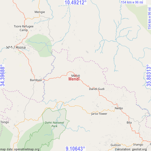
Mendī GPS coordinates[2]
9° 48' 0" North, 35° 6' 0" East
| Map corner | latitude | longitude |
|---|---|---|
| Upper-left | 10.49212°, | 34.39688° |
| Center: | 9.8°, | 35.1° |
| Lower-right: | 9.10643°, | 35.80313° |
| Map W x H: | 154.1×154.1 km | = 95.8×95.8mi |
| max Lat: | 14.277° ⇑33.6% North |
| Mendī: | 9.8° |
| min Lat: | ⇓66.4% South 4.05° |
| min Long | Mendī | max Long |
| 34.53333° | 35.1° | 42.8° |
| W 2.8%⇐ | ⇒97.2% E |
Elevation
Elevation of Mendī is 1665 m = 5463 ft, and this is 230.6 m = 757 ft below average elevation for this country.
| Max E: |
2854 m = 9364 ft | 72.9% |
| Avg. | 1895.6 m = 6219 ft | |
| Mendī | 1665 m = 5463 ft | |
Min E: |
367 m = 1204 ft | 27.1% |
See also: Ethiopia elevation on elevation.city.
Geographical zone
Mendī is located in North Torrid zone (between Equator and Tropic of Cancer). Distance of Equator is 1089.7 km =677.1 mi to South.| Distance of | km | miles | from Mendī |
|---|---|---|---|
| North Pole | 8917.4 | 5541 | to North |
| Arctic Circle | 6311.5 | 3921.8 | to North |
| Tropic Cancer | 1516.3 | 942.2 | to North |
| Equator | 1089.7 | 677.1 | to South |


Nearby cities:
15 places around Mendī: (largest is in red/bold)
• Bedelē
203.1 km =126.2 mi,  137°
137°
• Burē
237.3 km =147.5 mi,  65°
65°
• Debre Mark’os
294.7 km =183.1 mi,  78°
78°
• Dembī Dolo
144.6 km =89.9 mi,  193°
193°
• Finote Selam
257.3 km =159.9 mi, 67°
• Gambēla
181.4 km =112.7 mi,  198°
198°
• Gimbi
106.8 km =66.4 mi,  130°
130°
• Gorē
189.5 km =117.7 mi,  165°
165°
• Gēdo
272.1 km =169.1 mi,  108°
108°
• Metu
175 km =108.7 mi,  162°
162°
• Nejo
55.1 km =34.2 mi, 127°
• Shambu
220.7 km =137.1 mi,  96°
96°
• Tippi
291.6 km =181.2 mi, 172°
• Āgaro
275.7 km =171.3 mi, 141°
• Āsosa
68.8 km =42.8 mi,  295°
295°
Sources, notices
• [Note1] Compared only with cities in Ethiopia existing in our database
• [Src1] Map data: © OpenStreetMap contributors (CC-BY-SA)
• [Src2] Other city data from geonames.org with taken over terms of usage.
• [Src3] Geographical zone / Annual Mean Temperature by Robert A. Rohde @ Wikipedia
