Addiet Canna geodata
Addiet Canna (Amhara) is a populated place; located in Ethiopia in Africa/Addis_Ababa (GMT+3) time zone. With population of 22,946 people, there are 59 cities with bigger population in this country. Compared to other cities in Ethiopia, 83.2% of cities are located further ↓South; 75.7% of cities are located further →East and 71% of cities have lower elevation than Addiet Canna. Note1


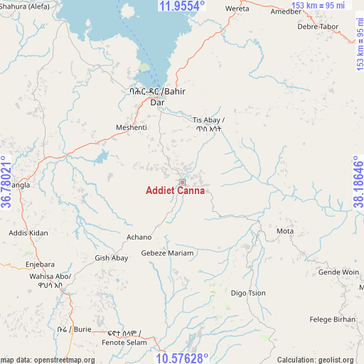
Addiet Canna GPS coordinates[2]
11° 16' 0.012" North, 37° 28' 59.988" East
| Map corner | latitude | longitude |
|---|---|---|
| Upper-left | 11.9554°, | 36.78021° |
| Center: | 11.26667°, | 37.48333° |
| Lower-right: | 10.57628°, | 38.18646° |
| Map W x H: | 153.3×153.3 km | = 95.3×95.3mi |
| max Lat: | 14.277° ⇑16.8% North |
| Addiet Canna: | 11.26667° |
| min Lat: | ⇓83.2% South 4.05° |
| min Long | Addiet Canna | max Long |
| 34.53333° | 37.48333° | 42.8° |
| W 24.3%⇐ | ⇒75.7% E |
Elevation
Elevation of Addiet Canna is 2203 m = 7228 ft, and this is 307.4 m = 1009 ft above average elevation for this country.
| Max E: |
2854 m = 9364 ft | 29% |
| Addiet Canna | 2203 m 7228 ft | |
| Avg. | 1895.6 m = 6219 ft | |
Min E: |
367 m = 1204 ft | 71% |
See also: Ethiopia elevation on elevation.city.
Geographical zone
Addiet Canna is located in North Torrid zone (between Equator and Tropic of Cancer). Distance of Equator is 1252.7 km =778.4 mi to South.| Distance of | km | miles | from Addiet Canna |
|---|---|---|---|
| North Pole | 8754.3 | 5439.7 | to North |
| Arctic Circle | 6148.4 | 3820.4 | to North |
| Tropic Cancer | 1353.2 | 840.8 | to North |
| Equator | 1252.7 | 778.4 | to South |


Nearby cities:
15 places around Addiet Canna: (largest is in red/bold)
• Bahir Dar
37.7 km =23.4 mi,  344°
344°
• Bichena
119.9 km =74.5 mi,  139°
139°
• Burē
77.7 km =48.3 mi,  215°
215°
• Dabat
193.4 km =120.2 mi,  9°
9°
• Debre Mark’os
105.5 km =65.6 mi,  165°
165°
• Debre Tabor
87.1 km =54.1 mi,  41°
41°
• Debre Werk’
100.1 km =62.2 mi,  131°
131°
• Dejen
141.4 km =87.9 mi,  149°
149°
• Finote Selam
67.3 km =41.8 mi,  200°
200°
• Gebre Guracha
191.4 km =118.9 mi, 148°
• Gondar
148.3 km =92.1 mi,  359°
359°
• Lalībela
190.4 km =118.3 mi,  63°
63°
• Shambu
193.6 km =120.3 mi,  192°
192°
• Werota
76 km =47.2 mi,  18°
18°
• Ādīs Zemen
100 km =62.1 mi, 19°
Sources, notices
• [Note1] Compared only with cities in Ethiopia existing in our database
• [Src1] Map data: © OpenStreetMap contributors (CC-BY-SA)
• [Src2] Other city data from geonames.org with taken over terms of usage.
• [Src3] Geographical zone / Annual Mean Temperature by Robert A. Rohde @ Wikipedia
