Laragne-Montéglin geodata
Laragne-Montéglin (Provence-Alpes-Côte d'Azur) is a populated place; located in France in Europe/Paris (GMT+2) time zone. With population of 3,556 people, there are 2741 cities with bigger population in this country. Compared to other cities in France, 84.8% of cities are located further ↑North; 85.3% of cities are located further ←West and 94.8% of cities have lower elevation than Laragne-Montéglin. Note1
Administrative division(s):
- Level 1: Provence-Alpes-Côte d'Azur
- Level 2: Hautes-Alpes
- Level 3: Arrondissement de Gap
- Level 4: Laragne-Montéglin


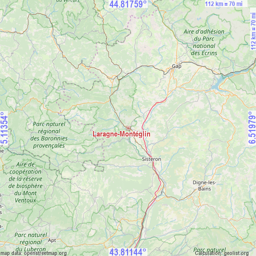
Laragne-Montéglin GPS coordinates[2]
44° 19' 0.012" North, 5° 49' 0.012" East
| Map corner | latitude | longitude |
|---|---|---|
| Upper-left | 44.81759°, | 5.11354° |
| Center: | 44.31667°, | 5.81667° |
| Lower-right: | 43.81144°, | 6.51979° |
| Map W x H: | 111.9×111.9 km | = 69.5×69.5mi |
| max Lat: | 51.07786° ⇑84.8% North |
| Laragne-Montéglin: | 44.31667° |
| min Lat: | ⇓15.2% South 41.3874° |
| min Long | Laragne-Montég | max Long |
| -5.08615° | 5.81667° | 9.52242° |
| W 85.3%⇐ | ⇒14.7% E |
Elevation
Elevation of Laragne-Montéglin is 577 m = 1893 ft, and this is 383.3 m = 1258 ft above average elevation for this country.
| Max E: |
2333 m = 7654 ft | 5.2% |
| Laragne-Montéglin | 577 m 1893 ft | |
| Avg. | 193.7 m = 635 ft | |
Min E: |
-1 m = -3 ft | 94.8% |
See also: France elevation on elevation.city.
Geographical zone
Laragne-Montéglin is located in North temperate zone (between Tropic of Cancer and the Arctic Circle). Distance of this Northern Tropic circle is 2321.6 km =1442.6 mi to South.| Distance of | km | miles | from Laragne-Montéglin |
|---|---|---|---|
| North Pole | 5079.5 | 3156.3 | to North |
| Arctic Circle | 2473.6 | 1537 | to North |
| Tropic Cancer | 2321.6 | 1442.6 | to South |
| Equator | 4927.6 | 3061.9 | to South |


Nearby cities:
15 places around Laragne-Montéglin: (largest is in red/bold)
• Aspres-sur-Buëch
23.4 km =14.5 mi,  347°
347°
• Aubignosc
24.1 km =15 mi,  149°
149°
• La Motte-du-Caire
17.1 km =10.6 mi,  79°
79°
• La Saulce
19.4 km =12.1 mi,  51°
51°
• Mison
6.1 km =3.8 mi,  162°
162°
• Neffes
26.5 km =16.5 mi,  37°
37°
• Peipin
22.8 km =14.2 mi, 150°
• Ribiers
10 km =6.2 mi, 161°
• Serres
14.8 km =9.2 mi,  326°
326°
• Sigoyer
21.9 km =13.6 mi, 35°
• Sisteron
17.5 km =10.9 mi,  143°
143°
• Tallard
24.7 km =15.3 mi, 49°
• Ventavon
9.3 km =5.8 mi, 49°
• Veynes
24.2 km =15 mi,  1°
1°
• Volonne
27.8 km =17.3 mi, 145°
Sources, notices
• [Note1] Compared only with cities in France existing in our database
• [Src1] Map data: © OpenStreetMap contributors (CC-BY-SA)
• [Src2] Other city data from geonames.org with taken over terms of usage.
• [Src3] Geographical zone / Annual Mean Temperature by Robert A. Rohde @ Wikipedia
