Elmina geodata
Elmina (Central) is a populated place; located in Ghana in Africa/Accra (GMT+0) time zone. With population of 25,560 people, there are 47 cities with bigger population in this country. Compared to other cities in Ghana, 94.4% of cities are located further ↑North; 63.9% of cities are located further →East and 87.5% of cities have higher elevation than Elmina. Note1


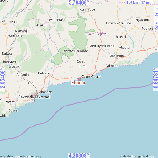
Elmina GPS coordinates[2]
5° 5' 4.92" North, 1° 21' 3.348" West
| Map corner | latitude | longitude |
|---|---|---|
| Upper-left | 5.78466°, | -2.05406° |
| Center: | 5.0847°, | -1.35093° |
| Lower-right: | 4.38398°, | -0.64781° |
| Map W x H: | 155.7×155.7 km | = 96.7×96.7mi |
| max Lat: | 11.0616° ⇑94.4% North |
| Elmina: | 5.0847° |
| min Lat: | ⇓5.6% South 4.86641° |
| min Long | Elmina | max Long |
| -2.78516° | -1.35093° | 1.19012° |
| W 36.1%⇐ | ⇒63.9% E |
Elevation
Elevation of Elmina is 21 m = 69 ft, and this is 149.2 m = 490 ft below average elevation for this country.
| Max E: |
477 m = 1565 ft | 87.5% |
| Avg. | 170.2 m = 558 ft | |
| Elmina | 21 m = 69 ft | |
Min E: |
0 m = 0 ft | 12.5% |
See also: Ghana elevation on elevation.city.
Geographical zone
Elmina is located in North Torrid zone (between Equator and Tropic of Cancer). Distance of Equator is 565.4 km =351.3 mi to South.| Distance of | km | miles | from Elmina |
|---|---|---|---|
| North Pole | 9441.7 | 5866.8 | to North |
| Arctic Circle | 6835.8 | 4247.6 | to North |
| Tropic Cancer | 2040.6 | 1268 | to North |
| Equator | 565.4 | 351.3 | to South |


Nearby cities:
15 places around Elmina: (largest is in red/bold)
• Aboso
72.9 km =45.3 mi,  294°
294°
• Akim Swedru
97.3 km =60.5 mi,  22°
22°
• Apam
71.5 km =44.4 mi,  71°
71°
• Axim
101.6 km =63.1 mi,  256°
256°
• Cape Coast
11.8 km =7.3 mi,  78°
78°
• Foso
68.9 km =42.8 mi,  5°
5°
• Mumford
68.4 km =42.5 mi, 73°
• Prestea
95.9 km =59.6 mi, 293°
• Saltpond
35 km =21.7 mi, 66°
• Sekondi-Takoradi
48.4 km =30.1 mi,  248°
248°
• Shama Junction
35.5 km =22.1 mi, 257°
• Swedru
87.9 km =54.6 mi,  55°
55°
• Takoradi
49.9 km =31 mi, 245°
• Tarkwa
74.8 km =46.5 mi, 289°
• Winneba
85.9 km =53.4 mi, 69°
Sources, notices
• [Note1] Compared only with cities in Ghana existing in our database
• [Src1] Map data: © OpenStreetMap contributors (CC-BY-SA)
• [Src2] Other city data from geonames.org with taken over terms of usage.
• [Src3] Geographical zone / Annual Mean Temperature by Robert A. Rohde @ Wikipedia
