Savelugu geodata
Savelugu (Northern) is a populated place; located in Ghana in Africa/Accra (GMT+0) time zone. With population of 29,310 people, there are 45 cities with bigger population in this country. Compared to other cities in Ghana, 94.4% of cities are located further ↓South; 51.4% of cities are located further ←West and 51.4% of cities have lower elevation than Savelugu. Note1


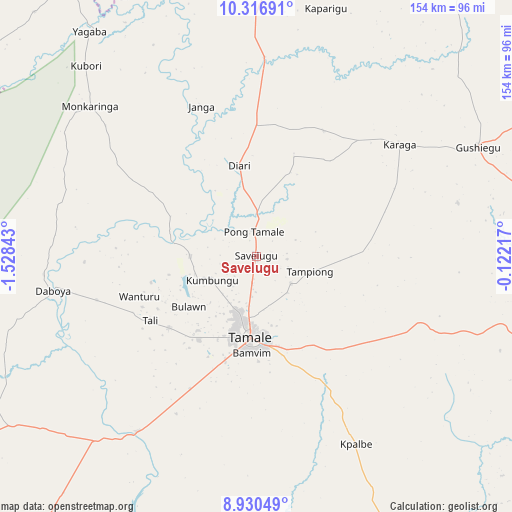
Savelugu GPS coordinates[2]
9° 37' 27.876" North, 0° 49' 31.08" West
| Map corner | latitude | longitude |
|---|---|---|
| Upper-left | 10.31691°, | -1.52843° |
| Center: | 9.62441°, | -0.8253° |
| Lower-right: | 8.93049°, | -0.12217° |
| Map W x H: | 154.2×154.2 km | = 95.8×95.8mi |
| max Lat: | 11.0616° ⇑5.6% North |
| Savelugu: | 9.62441° |
| min Lat: | ⇓94.4% South 4.86641° |
| min Long | Savelugu | max Long |
| -2.78516° | -0.8253° | 1.19012° |
| W 51.4%⇐ | ⇒48.6% E |
Elevation
Elevation of Savelugu is 169 m = 554 ft, and this is 1.2 m = 4 ft below average elevation for this country.
| Max E: |
477 m = 1565 ft | 48.6% |
| Avg. | 170.2 m = 558 ft | |
| Savelugu | 169 m = 554 ft | |
Min E: |
0 m = 0 ft | 51.4% |
See also: Ghana elevation on elevation.city.
Geographical zone
Savelugu is located in North Torrid zone (between Equator and Tropic of Cancer). Distance of Equator is 1070.1 km =664.9 mi to South.| Distance of | km | miles | from Savelugu |
|---|---|---|---|
| North Pole | 8936.9 | 5553.1 | to North |
| Arctic Circle | 6331 | 3933.9 | to North |
| Tropic Cancer | 1535.8 | 954.3 | to North |
| Equator | 1070.1 | 664.9 | to South |


Nearby cities:
15 places around Savelugu: (largest is in red/bold)
• Bawku
172.1 km =106.9 mi,  21°
21°
• Bolgatanga
129.1 km =80.2 mi,  358°
358°
• Ejura
255.7 km =158.9 mi,  193°
193°
• Kete Krachi
220.7 km =137.1 mi,  157°
157°
• Kintampo
200.7 km =124.7 mi,  209°
209°
• Kpandae
156.5 km =97.2 mi,  145°
145°
• Mampong
291.8 km =181.3 mi, 192°
• Navrongo
144.3 km =89.7 mi,  348°
348°
• Salaga
124 km =77.1 mi, 164°
• Sunyani
303 km =188.3 mi, 213°
• Tamale
24.9 km =15.5 mi,  183°
183°
• Techiman
257.7 km =160.1 mi, 208°
• Wa
190 km =118.1 mi,  284°
284°
• Wenchi
252.4 km =156.8 mi, 213°
• Yendi
91.7 km =57 mi,  102°
102°
Sources, notices
• [Note1] Compared only with cities in Ghana existing in our database
• [Src1] Map data: © OpenStreetMap contributors (CC-BY-SA)
• [Src2] Other city data from geonames.org with taken over terms of usage.
• [Src3] Geographical zone / Annual Mean Temperature by Robert A. Rohde @ Wikipedia
