Tamale geodata
Tamale (Northern) is a seat of a first-order administrative division; located in Ghana in Africa/Accra (GMT+0) time zone. With population of 360,579 people, there are 2 cities with bigger population in this country. Compared to other cities in Ghana, 91.7% of cities are located further ↓South; 50% of cities are located further ←West and 61.1% of cities have lower elevation than Tamale. Note1


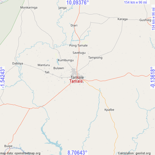
Tamale GPS coordinates[2]
9° 24' 2.844" North, 0° 50' 21.48" West
| Map corner | latitude | longitude |
|---|---|---|
| Upper-left | 10.09376°, | -1.54243° |
| Center: | 9.40079°, | -0.8393° |
| Lower-right: | 8.70643°, | -0.13618° |
| Map W x H: | 154.3×154.3 km | = 95.9×95.9mi |
| max Lat: | 11.0616° ⇑8.3% North |
| Tamale: | 9.40079° |
| min Lat: | ⇓91.7% South 4.86641° |
| min Long | Tamale | max Long |
| -2.78516° | -0.8393° | 1.19012° |
| W 50%⇐ | ⇒50% E |
Elevation
Elevation of Tamale is 196 m = 643 ft, and this is 25.8 m = 85 ft above average elevation for this country.
| Max E: |
477 m = 1565 ft | 38.9% |
| Tamale | 196 m 643 ft | |
| Avg. | 170.2 m = 558 ft | |
Min E: |
0 m = 0 ft | 61.1% |
See also: Tamale elevation on elevation.city.
Geographical zone
Tamale is located in North Torrid zone (between Equator and Tropic of Cancer). Distance of Equator is 1045.3 km =649.5 mi to South.| Distance of | km | miles | from Tamale |
|---|---|---|---|
| North Pole | 8961.8 | 5568.6 | to North |
| Arctic Circle | 6355.9 | 3949.4 | to North |
| Tropic Cancer | 1560.6 | 969.7 | to North |
| Equator | 1045.3 | 649.5 | to South |


Nearby cities:
15 places around Tamale: (largest is in red/bold)
• Bawku
195.9 km =121.7 mi,  19°
19°
• Bolgatanga
154 km =95.7 mi,  359°
359°
• Ejura
231.2 km =143.7 mi,  194°
194°
• Kete Krachi
198.6 km =123.4 mi,  154°
154°
• Kintampo
178.7 km =111 mi,  213°
213°
• Kpandae
137.9 km =85.7 mi,  138°
138°
• Mampong
267.2 km =166 mi, 193°
• Navrongo
168.5 km =104.7 mi,  350°
350°
• Salaga
100.9 km =62.7 mi,  159°
159°
• Savelugu
24.9 km =15.5 mi,  3°
3°
• Sunyani
281.6 km =175 mi,  215°
215°
• Techiman
235.4 km =146.3 mi, 210°
• Wa
196.4 km =122 mi,  291°
291°
• Wenchi
231.3 km =143.7 mi, 216°
• Yendi
91.1 km =56.6 mi,  87°
87°
Sources, notices
• [Note1] Compared only with cities in Ghana existing in our database
• [Src1] Map data: © OpenStreetMap contributors (CC-BY-SA)
• [Src2] Other city data from geonames.org with taken over terms of usage.
• [Src3] Geographical zone / Annual Mean Temperature by Robert A. Rohde @ Wikipedia
