Prestea geodata
Prestea (Western) is a populated place; located in Ghana in Africa/Accra (GMT+0) time zone. With population of 35,155 people, there are 38 cities with bigger population in this country. Compared to other cities in Ghana, 83.3% of cities are located further ↑North; 91.7% of cities are located further →East and 70.8% of cities have higher elevation than Prestea. Note1


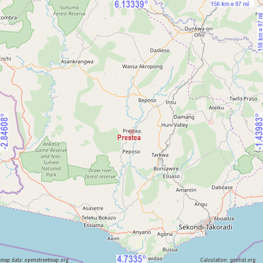
Prestea GPS coordinates[2]
5° 26' 1.86" North, 2° 8' 34.62" West
| Map corner | latitude | longitude |
|---|---|---|
| Upper-left | 6.13339°, | -2.84608° |
| Center: | 5.43385°, | -2.14295° |
| Lower-right: | 4.7335°, | -1.43983° |
| Map W x H: | 155.7×155.7 km | = 96.7×96.7mi |
| max Lat: | 11.0616° ⇑83.3% North |
| Prestea: | 5.43385° |
| min Lat: | ⇓16.7% South 4.86641° |
| min Long | Prestea | max Long |
| -2.78516° | -2.14295° | 1.19012° |
| W 8.3%⇐ | ⇒91.7% E |
Elevation
Elevation of Prestea is 69 m = 226 ft, and this is 101.2 m = 332 ft below average elevation for this country.
| Max E: |
477 m = 1565 ft | 70.8% |
| Avg. | 170.2 m = 558 ft | |
| Prestea | 69 m = 226 ft | |
Min E: |
0 m = 0 ft | 29.2% |
See also: Ghana elevation on elevation.city.
Geographical zone
Prestea is located in North Torrid zone (between Equator and Tropic of Cancer). Distance of Equator is 604.2 km =375.4 mi to South.| Distance of | km | miles | from Prestea |
|---|---|---|---|
| North Pole | 9402.9 | 5842.7 | to North |
| Arctic Circle | 6797 | 4223.5 | to North |
| Tropic Cancer | 2001.7 | 1243.8 | to North |
| Equator | 604.2 | 375.4 | to South |


Nearby cities:
15 places around Prestea: (largest is in red/bold)
• Aboso
23 km =14.3 mi,  110°
110°
• Axim
64 km =39.8 mi,  189°
189°
• Bekwai
129.3 km =80.3 mi,  28°
28°
• Bibiani
116.1 km =72.1 mi,  350°
350°
• Cape Coast
105.8 km =65.7 mi, 110°
• Dunkwa
71.1 km =44.2 mi, 34°
• Elmina
95.9 km =59.6 mi, 113°
• Foso
99.3 km =61.7 mi,  72°
72°
• Obuase
100.3 km =62.3 mi, 31°
• Saltpond
122.4 km =76.1 mi,  101°
101°
• Sekondi-Takoradi
70.7 km =43.9 mi,  142°
142°
• Shama Junction
70.3 km =43.7 mi,  131°
131°
• Takoradi
73.1 km =45.4 mi, 144°
• Tarkwa
22.3 km =13.9 mi, 130°
• Wassa-Akropong
39.8 km =24.7 mi,  9°
9°
Sources, notices
• [Note1] Compared only with cities in Ghana existing in our database
• [Src1] Map data: © OpenStreetMap contributors (CC-BY-SA)
• [Src2] Other city data from geonames.org with taken over terms of usage.
• [Src3] Geographical zone / Annual Mean Temperature by Robert A. Rohde @ Wikipedia
