Aboso geodata
Aboso (Western) is a populated place; located in Ghana in Africa/Accra (GMT+0) time zone. With population of 8,790 people, there are 67 cities with bigger population in this country. Compared to other cities in Ghana, 84.7% of cities are located further ↑North; 83.3% of cities are located further →East and 69.4% of cities have higher elevation than Aboso. Note1


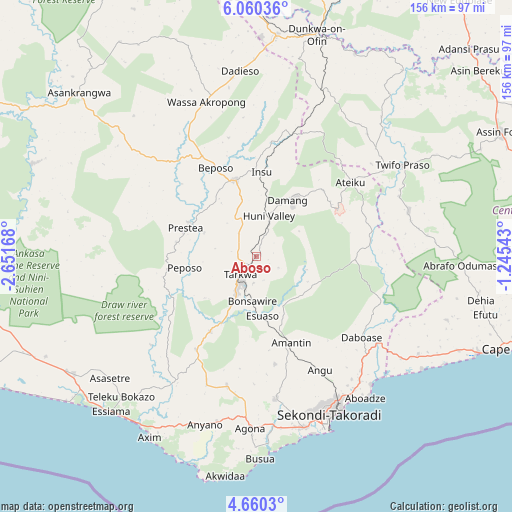
Aboso GPS coordinates[2]
5° 21' 38.628" North, 1° 56' 54.816" West
| Map corner | latitude | longitude |
|---|---|---|
| Upper-left | 6.06036°, | -2.65168° |
| Center: | 5.36073°, | -1.94856° |
| Lower-right: | 4.6603°, | -1.24543° |
| Map W x H: | 155.7×155.7 km | = 96.7×96.7mi |
| max Lat: | 11.0616° ⇑84.7% North |
| Aboso: | 5.36073° |
| min Lat: | ⇓15.3% South 4.86641° |
| min Long | Aboso | max Long |
| -2.78516° | -1.94856° | 1.19012° |
| W 16.7%⇐ | ⇒83.3% E |
Elevation
Elevation of Aboso is 73 m = 240 ft, and this is 97.2 m = 319 ft below average elevation for this country.
| Max E: |
477 m = 1565 ft | 69.4% |
| Avg. | 170.2 m = 558 ft | |
| Aboso | 73 m = 240 ft | |
Min E: |
0 m = 0 ft | 30.6% |
See also: Ghana elevation on elevation.city.
Geographical zone
Aboso is located in North Torrid zone (between Equator and Tropic of Cancer). Distance of Equator is 596.1 km =370.4 mi to South.| Distance of | km | miles | from Aboso |
|---|---|---|---|
| North Pole | 9411 | 5847.7 | to North |
| Arctic Circle | 6805.1 | 4228.5 | to North |
| Tropic Cancer | 2009.9 | 1248.9 | to North |
| Equator | 596.1 | 370.4 | to South |


Nearby cities:
15 places around Aboso: (largest is in red/bold)
• Akim Oda
123.7 km =76.9 mi,  59°
59°
• Akim Swedru
119 km =73.9 mi, 60°
• Axim
63.8 km =39.6 mi,  210°
210°
• Cape Coast
82.7 km =51.4 mi,  110°
110°
• Dunkwa
69.3 km =43.1 mi,  15°
15°
• Elmina
72.9 km =45.3 mi, 114°
• Foso
82.5 km =51.3 mi, 62°
• Obuase
98.6 km =61.3 mi, 18°
• Prestea
23 km =14.3 mi,  290°
290°
• Saltpond
99.7 km =62 mi,  99°
99°
• Sekondi-Takoradi
52.7 km =32.7 mi,  156°
156°
• Shama Junction
49.4 km =30.7 mi,  140°
140°
• Takoradi
55.5 km =34.5 mi, 157°
• Tarkwa
7.8 km =4.8 mi,  215°
215°
• Wassa-Akropong
49.7 km =30.9 mi,  342°
342°
Sources, notices
• [Note1] Compared only with cities in Ghana existing in our database
• [Src1] Map data: © OpenStreetMap contributors (CC-BY-SA)
• [Src2] Other city data from geonames.org with taken over terms of usage.
• [Src3] Geographical zone / Annual Mean Temperature by Robert A. Rohde @ Wikipedia
