Nsang geodata
Nsang (Kié-Ntem) is a populated place; located in Equatorial Guinea in Africa/Malabo (GMT+1) time zone. With population of 2,122 people, there are 19 cities with bigger population in this country. Compared to other cities in Equatorial Guinea, 62.5% of cities are located further ↓South; 87.5% of cities are located further ←West and 75% of cities have lower elevation than Nsang. Note1


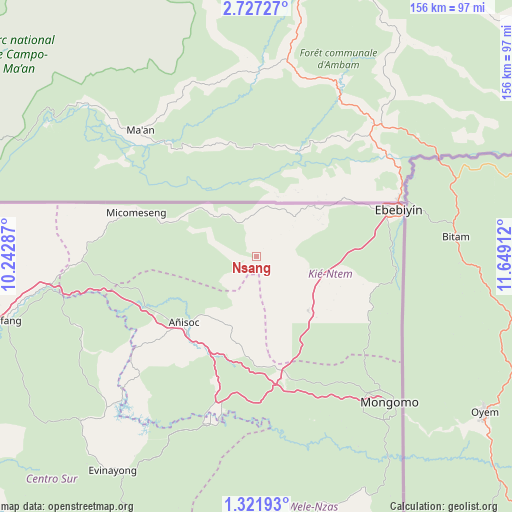
Nsang GPS coordinates[2]
2° 1' 29.1" North, 10° 56' 45.564" East
| Map corner | latitude | longitude |
|---|---|---|
| Upper-left | 2.72727°, | 10.24287° |
| Center: | 2.02475°, | 10.94599° |
| Lower-right: | 1.32193°, | 11.64912° |
| Map W x H: | 156.3×156.3 km | = 97.1×97.1mi |
| max Lat: | 3.75578° ⇑37.5% North |
| Nsang: | 2.02475° |
| min Lat: | ⇓62.5% South -1.4068° |
| min Long | Nsang | max Long |
| 5.63178° | 10.94599° | 11.33528° |
| W 87.5%⇐ | ⇒12.5% E |
Elevation
Elevation of Nsang is 589 m = 1932 ft, and this is 217 m = 712 ft above average elevation for this country.
| Max E: |
1278 m = 4193 ft | 25% |
| Nsang | 589 m 1932 ft | |
| Avg. | 372 m = 1220 ft | |
Min E: |
4 m = 13 ft | 75% |
See also: Equatorial Guinea elevation on elevation.city.
Geographical zone
Nsang is located in North Torrid zone (between Equator and Tropic of Cancer). Distance of Equator is 225.1 km =139.9 mi to South.| Distance of | km | miles | from Nsang |
|---|---|---|---|
| North Pole | 9781.9 | 6078.2 | to North |
| Arctic Circle | 7176 | 4459 | to North |
| Tropic Cancer | 2380.8 | 1479.4 | to North |
| Equator | 225.1 | 139.9 | to South |


Nearby cities:
15 places around Nsang: (largest is in red/bold)
• Aconibe
80.9 km =50.3 mi,  180°
180°
• Acurenam
115.2 km =71.6 mi,  196°
196°
• Ayene
34.1 km =21.2 mi,  236°
236°
• Añisoc
26.4 km =16.4 mi,  228°
228°
• Bata
132.4 km =82.3 mi,  262°
262°
• Bicurga
72.6 km =45.1 mi, 227°
• Ebebiyin
45.5 km =28.3 mi,  72°
72°
• Evinayong
78.7 km =48.9 mi,  213°
213°
• Machinda
111.7 km =69.4 mi, 261°
• Mbini
155.9 km =96.9 mi,  251°
251°
• Mikomeseng
39 km =24.2 mi,  288°
288°
• Mongomo
60.2 km =37.4 mi,  137°
137°
• Ncue
52.8 km =32.8 mi,  268°
268°
• Nsok
105.7 km =65.7 mi,  160°
160°
• Río Campo
129.6 km =80.5 mi, 285°
Sources, notices
• [Note1] Compared only with cities in Equatorial Guinea existing in our database
• [Src1] Map data: © OpenStreetMap contributors (CC-BY-SA)
• [Src2] Other city data from geonames.org with taken over terms of usage.
• [Src3] Geographical zone / Annual Mean Temperature by Robert A. Rohde @ Wikipedia
