Aconibe geodata
Aconibe (Wele-Nzas) is a populated place; located in Equatorial Guinea in Africa/Malabo (GMT+1) time zone. With population of 11,192 people, there are 3 cities with bigger population in this country. Compared to other cities in Equatorial Guinea, 83.3% of cities are located further ↑North; 83.3% of cities are located further ←West and 95.8% of cities have lower elevation than Aconibe. Note1


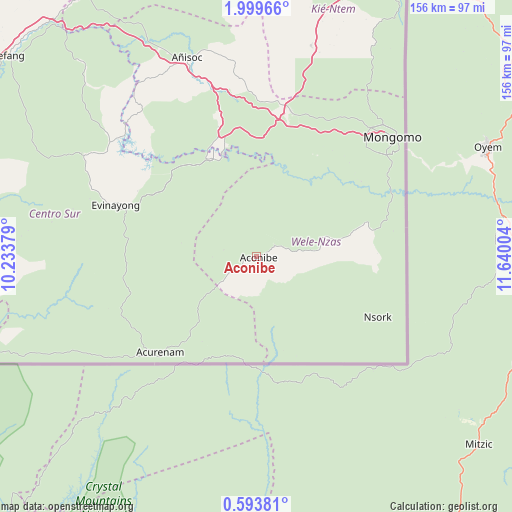
Aconibe GPS coordinates[2]
1° 17' 48.588" North, 10° 56' 12.876" East
| Map corner | latitude | longitude |
|---|---|---|
| Upper-left | 1.99966°, | 10.23379° |
| Center: | 1.29683°, | 10.93691° |
| Lower-right: | 0.59381°, | 11.64004° |
| Map W x H: | 156.3×156.3 km | = 97.1×97.1mi |
| max Lat: | 3.75578° ⇑83.3% North |
| Aconibe: | 1.29683° |
| min Lat: | ⇓16.7% South -1.4068° |
| min Long | Aconibe | max Long |
| 5.63178° | 10.93691° | 11.33528° |
| W 83.3%⇐ | ⇒16.7% E |
Elevation
Elevation of Aconibe is 683 m = 2241 ft, and this is 311 m = 1020 ft above average elevation for this country.
| Max E: |
1278 m = 4193 ft | 4.2% |
| Aconibe | 683 m 2241 ft | |
| Avg. | 372 m = 1220 ft | |
Min E: |
4 m = 13 ft | 95.8% |
See also: Equatorial Guinea elevation on elevation.city.
Geographical zone
Aconibe is located in North Torrid zone (between Equator and Tropic of Cancer). Distance of Equator is 144.2 km =89.6 mi to South.| Distance of | km | miles | from Aconibe |
|---|---|---|---|
| North Pole | 9862.9 | 6128.5 | to North |
| Arctic Circle | 7257 | 4509.3 | to North |
| Tropic Cancer | 2461.7 | 1529.6 | to North |
| Equator | 144.2 | 89.6 | to South |


Nearby cities:
15 places around Aconibe: (largest is in red/bold)
• Acurenam
43.5 km =27 mi,  227°
227°
• Ayene
68 km =42.3 mi,  336°
336°
• Añisoc
66 km =41 mi, 343°
• Bata
144.6 km =89.9 mi,  295°
295°
• Bicurga
61 km =37.9 mi, 301°
• Bitica
146.7 km =91.2 mi,  275°
275°
• Cogo
140.3 km =87.2 mi,  260°
260°
• Ebebiyin
104.8 km =65.1 mi,  24°
24°
• Evinayong
45.6 km =28.3 mi,  289°
289°
• Machinda
127.4 km =79.2 mi, 300°
• Mikomeseng
100 km =62.1 mi, 338°
• Mongomo
55.7 km =34.6 mi,  48°
48°
• Ncue
95.3 km =59.2 mi,  327°
327°
• Nsang
80.9 km =50.3 mi,  0°
0°
• Nsok
41 km =25.5 mi,  116°
116°
Sources, notices
• [Note1] Compared only with cities in Equatorial Guinea existing in our database
• [Src1] Map data: © OpenStreetMap contributors (CC-BY-SA)
• [Src2] Other city data from geonames.org with taken over terms of usage.
• [Src3] Geographical zone / Annual Mean Temperature by Robert A. Rohde @ Wikipedia
