Evinayong geodata
Evinayong (Centro Sur) is a seat of a first-order administrative division; located in Equatorial Guinea in Africa/Malabo (GMT+1) time zone. With population of 8,462 people, there are 6 cities with bigger population in this country. Compared to other cities in Equatorial Guinea, 75% of cities are located further ↑North; 62.5% of cities are located further ←West and 91.7% of cities have lower elevation than Evinayong. Note1


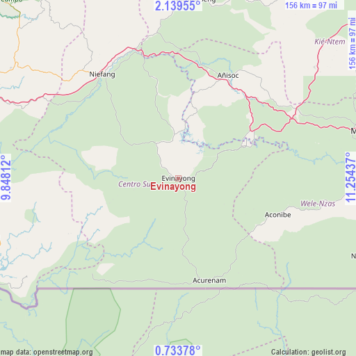
Evinayong GPS coordinates[2]
1° 26' 12.372" North, 10° 33' 4.464" East
| Map corner | latitude | longitude |
|---|---|---|
| Upper-left | 2.13955°, | 9.84812° |
| Center: | 1.43677°, | 10.55124° |
| Lower-right: | 0.73378°, | 11.25437° |
| Map W x H: | 156.3×156.3 km | = 97.1×97.1mi |
| max Lat: | 3.75578° ⇑75% North |
| Evinayong: | 1.43677° |
| min Lat: | ⇓25% South -1.4068° |
| min Long | Evinayong | max Long |
| 5.63178° | 10.55124° | 11.33528° |
| W 62.5%⇐ | ⇒37.5% E |
Elevation
Elevation of Evinayong is 669 m = 2195 ft, and this is 297 m = 974 ft above average elevation for this country.
| Max E: |
1278 m = 4193 ft | 8.3% |
| Evinayong | 669 m 2195 ft | |
| Avg. | 372 m = 1220 ft | |
Min E: |
4 m = 13 ft | 91.7% |
See also: Equatorial Guinea elevation on elevation.city.
Geographical zone
Evinayong is located in North Torrid zone (between Equator and Tropic of Cancer). Distance of Equator is 159.8 km =99.3 mi to South.| Distance of | km | miles | from Evinayong |
|---|---|---|---|
| North Pole | 9847.3 | 6118.8 | to North |
| Arctic Circle | 7241.4 | 4499.6 | to North |
| Tropic Cancer | 2446.2 | 1520 | to North |
| Equator | 159.8 | 99.3 | to South |


Nearby cities:
15 places around Evinayong: (largest is in red/bold)
• Aconibe
45.6 km =28.3 mi,  109°
109°
• Acurenam
46.3 km =28.8 mi,  166°
166°
• Ayene
49.1 km =30.5 mi,  18°
18°
• Añisoc
53.5 km =33.2 mi,  26°
26°
• Bata
99.4 km =61.8 mi,  298°
298°
• Bicurga
18.6 km =11.6 mi,  329°
329°
• Bitica
103.2 km =64.1 mi,  269°
269°
• Cogo
103.1 km =64.1 mi,  247°
247°
• Machinda
83.1 km =51.6 mi,  306°
306°
• Mbini
105.3 km =65.4 mi,  278°
278°
• Mikomeseng
78.1 km =48.5 mi,  5°
5°
• Mongomo
87.3 km =54.2 mi,  75°
75°
• Ncue
65.1 km =40.5 mi,  352°
352°
• Nsang
78.7 km =48.9 mi, 33°
• Nsok
86.5 km =53.7 mi, 113°
Sources, notices
• [Note1] Compared only with cities in Equatorial Guinea existing in our database
• [Src1] Map data: © OpenStreetMap contributors (CC-BY-SA)
• [Src2] Other city data from geonames.org with taken over terms of usage.
• [Src3] Geographical zone / Annual Mean Temperature by Robert A. Rohde @ Wikipedia
