Mongomo geodata
Mongomo (Wele-Nzas) is a seat of a first-order administrative division; located in Equatorial Guinea in Africa/Malabo (GMT+1) time zone. With population of 6,393 people, there are 7 cities with bigger population in this country. Compared to other cities in Equatorial Guinea, 62.5% of cities are located further ↑North; 95.8% of cities are located further ←West and 79.2% of cities have lower elevation than Mongomo. Note1


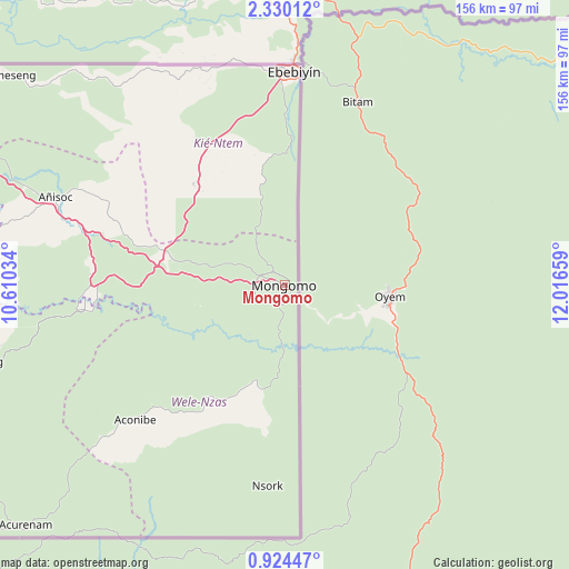
Mongomo GPS coordinates[2]
1° 37' 38.712" North, 11° 18' 48.456" East
| Map corner | latitude | longitude |
|---|---|---|
| Upper-left | 2.33012°, | 10.61034° |
| Center: | 1.62742°, | 11.31346° |
| Lower-right: | 0.92447°, | 12.01659° |
| Map W x H: | 156.3×156.3 km | = 97.1×97.1mi |
| max Lat: | 3.75578° ⇑62.5% North |
| Mongomo: | 1.62742° |
| min Lat: | ⇓37.5% South -1.4068° |
| min Long | Mongomo | max Long |
| 5.63178° | 11.31346° | 11.33528° |
| W 95.8%⇐ | ⇒4.2% E |
Elevation
Elevation of Mongomo is 630 m = 2067 ft, and this is 258 m = 846 ft above average elevation for this country.
| Max E: |
1278 m = 4193 ft | 20.8% |
| Mongomo | 630 m 2067 ft | |
| Avg. | 372 m = 1220 ft | |
Min E: |
4 m = 13 ft | 79.2% |
See also: Equatorial Guinea elevation on elevation.city.
Geographical zone
Mongomo is located in North Torrid zone (between Equator and Tropic of Cancer). Distance of Equator is 181 km =112.5 mi to South.| Distance of | km | miles | from Mongomo |
|---|---|---|---|
| North Pole | 9826.1 | 6105.7 | to North |
| Arctic Circle | 7220.2 | 4486.4 | to North |
| Tropic Cancer | 2425 | 1506.8 | to North |
| Equator | 181 | 112.5 | to South |


Nearby cities:
15 places around Mongomo: (largest is in red/bold)
• Aconibe
55.7 km =34.6 mi,  228°
228°
• Acurenam
99.2 km =61.6 mi, 228°
• Ayene
73.8 km =45.9 mi,  290°
290°
• Añisoc
66.1 km =41.1 mi, 293°
• Bata
174 km =108.1 mi,  278°
278°
• Bicurga
94.2 km =58.5 mi,  266°
266°
• Ebebiyin
58.3 km =36.2 mi,  2°
2°
• Evinayong
87.3 km =54.2 mi,  255°
255°
• Machinda
154 km =95.7 mi, 280°
• Mbini
188.9 km =117.4 mi, 268°
• Mikomeseng
96.2 km =59.8 mi,  306°
306°
• Ncue
103.2 km =64.1 mi, 294°
• Nsang
60.2 km =37.4 mi,  317°
317°
• Nsok
55.6 km =34.5 mi,  185°
185°
• Río Campo
183.6 km =114.1 mi,  295°
295°
Sources, notices
• [Note1] Compared only with cities in Equatorial Guinea existing in our database
• [Src1] Map data: © OpenStreetMap contributors (CC-BY-SA)
• [Src2] Other city data from geonames.org with taken over terms of usage.
• [Src3] Geographical zone / Annual Mean Temperature by Robert A. Rohde @ Wikipedia
