Cogo geodata
Cogo (Litoral) is a populated place; located in Equatorial Guinea in Africa/Malabo (GMT+1) time zone. With population of 4,607 people, there are 10 cities with bigger population in this country. Compared to other cities in Equatorial Guinea, 91.7% of cities are located further ↑North; 62.5% of cities are located further →East and 100% of cities have higher elevation than Cogo. Note1


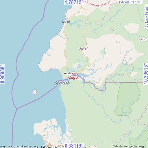
Cogo GPS coordinates[2]
1° 5' 3.3" North, 9° 41' 34.8" East
| Map corner | latitude | longitude |
|---|---|---|
| Upper-left | 1.78715°, | 8.98988° |
| Center: | 1.08425°, | 9.693° |
| Lower-right: | 0.38119°, | 10.39613° |
| Map W x H: | 156.3×156.3 km | = 97.1×97.1mi |
| max Lat: | 3.75578° ⇑91.7% North |
| Cogo: | 1.08425° |
| min Lat: | ⇓8.3% South -1.4068° |
| min Long | Cogo | max Long |
| 5.63178° | 9.693° | 11.33528° |
| W 37.5%⇐ | ⇒62.5% E |
Elevation
Elevation of Cogo is 4 m = 13 ft, and this is 368 m = 1207 ft below average elevation for this country.
| Max E: |
1278 m = 4193 ft | 100% |
| Avg. | 372 m = 1220 ft | |
| Cogo | 4 m = 13 ft | |
Min E: |
4 m = 13 ft | 0% |
See also: Equatorial Guinea elevation on elevation.city.
Geographical zone
Cogo is located in North Torrid zone (between Equator and Tropic of Cancer). Distance of Equator is 120.6 km =74.9 mi to South.| Distance of | km | miles | from Cogo |
|---|---|---|---|
| North Pole | 9886.5 | 6143.2 | to North |
| Arctic Circle | 7280.6 | 4524 | to North |
| Tropic Cancer | 2485.4 | 1544.4 | to North |
| Equator | 120.6 | 74.9 | to South |


Nearby cities:
15 places around Cogo: (largest is in red/bold)
• Aconibe
140.3 km =87.2 mi,  80°
80°
• Acurenam
106.4 km =66.1 mi,  93°
93°
• Ayene
140.1 km =87.1 mi,  52°
52°
• Añisoc
147.8 km =91.8 mi, 53°
• Bata
87.1 km =54.1 mi,  5°
5°
• Bicurga
102.3 km =63.6 mi,  57°
57°
• Bitica
38.8 km =24.1 mi,  348°
348°
• Evinayong
103.1 km =64.1 mi,  67°
67°
• Machinda
93.3 km =58 mi,  17°
17°
• Mbini
56.1 km =34.9 mi, 351°
• Mikomeseng
155.4 km =96.6 mi,  41°
41°
• Ncue
135 km =83.9 mi, 39°
• Nsang
174.2 km =108.2 mi, 53°
• Nsok
174.9 km =108.7 mi, 88°
• Río Campo
140.2 km =87.1 mi, 5°
Sources, notices
• [Note1] Compared only with cities in Equatorial Guinea existing in our database
• [Src1] Map data: © OpenStreetMap contributors (CC-BY-SA)
• [Src2] Other city data from geonames.org with taken over terms of usage.
• [Src3] Geographical zone / Annual Mean Temperature by Robert A. Rohde @ Wikipedia
