Nsok geodata
Nsok (Wele-Nzas) is a populated place; located in Equatorial Guinea in Africa/Malabo (GMT+1) time zone. With population of 3,769 people, there are 13 cities with bigger population in this country. Compared to other cities in Equatorial Guinea, 87.5% of cities are located further ↑North; 91.7% of cities are located further ←West and 66.7% of cities have lower elevation than Nsok. Note1


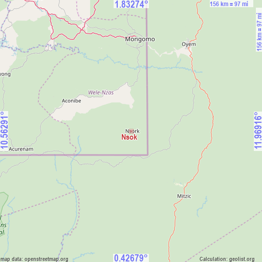
Nsok GPS coordinates[2]
1° 7' 47.46" North, 11° 15' 57.708" East
| Map corner | latitude | longitude |
|---|---|---|
| Upper-left | 1.83274°, | 10.56291° |
| Center: | 1.12985°, | 11.26603° |
| Lower-right: | 0.42679°, | 11.96916° |
| Map W x H: | 156.3×156.3 km | = 97.1×97.1mi |
| max Lat: | 3.75578° ⇑87.5% North |
| Nsok: | 1.12985° |
| min Lat: | ⇓12.5% South -1.4068° |
| min Long | Nsok | max Long |
| 5.63178° | 11.26603° | 11.33528° |
| W 91.7%⇐ | ⇒8.3% E |
Elevation
Elevation of Nsok is 552 m = 1811 ft, and this is 180 m = 591 ft above average elevation for this country.
| Max E: |
1278 m = 4193 ft | 33.3% |
| Nsok | 552 m 1811 ft | |
| Avg. | 372 m = 1220 ft | |
Min E: |
4 m = 13 ft | 66.7% |
See also: Equatorial Guinea elevation on elevation.city.
Geographical zone
Nsok is located in North Torrid zone (between Equator and Tropic of Cancer). Distance of Equator is 125.6 km =78 mi to South.| Distance of | km | miles | from Nsok |
|---|---|---|---|
| North Pole | 9881.4 | 6140 | to North |
| Arctic Circle | 7275.5 | 4520.8 | to North |
| Tropic Cancer | 2480.3 | 1541.2 | to North |
| Equator | 125.6 | 78 | to South |


Nearby cities:
15 places around Nsok: (largest is in red/bold)
• Aconibe
41 km =25.5 mi,  296°
296°
• Acurenam
69.5 km =43.2 mi,  261°
261°
• Ayene
103 km =64 mi,  321°
321°
• Añisoc
98.7 km =61.3 mi,  325°
325°
• Bata
185.7 km =115.4 mi, 296°
• Bicurga
102 km =63.4 mi, 299°
• Bitica
185.6 km =115.3 mi,  280°
280°
• Cogo
174.9 km =108.7 mi,  268°
268°
• Ebebiyin
113.8 km =70.7 mi,  3°
3°
• Evinayong
86.5 km =53.7 mi,  293°
293°
• Machinda
168.4 km =104.6 mi, 299°
• Mikomeseng
133.3 km =82.8 mi, 327°
• Mongomo
55.6 km =34.5 mi,  5°
5°
• Ncue
132.4 km =82.3 mi, 318°
• Nsang
105.7 km =65.7 mi,  340°
340°
Sources, notices
• [Note1] Compared only with cities in Equatorial Guinea existing in our database
• [Src1] Map data: © OpenStreetMap contributors (CC-BY-SA)
• [Src2] Other city data from geonames.org with taken over terms of usage.
• [Src3] Geographical zone / Annual Mean Temperature by Robert A. Rohde @ Wikipedia
