Lethem geodata
Lethem (Upper Takutu-Upper Essequibo) is a seat of a first-order administrative division; located in Guyana in America/Guyana (GMT-4) time zone. With population of 716 people, there are 13 cities with bigger population in this country. Compared to other cities in Guyana, 100% of cities are located further ↑North; 100% of cities are located further →East and 100% of cities have lower elevation than Lethem. Note1


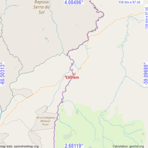
Lethem GPS coordinates[2]
3° 22' 59.988" North, 59° 48' 0" West
| Map corner | latitude | longitude |
|---|---|---|
| Upper-left | 4.08496°, | -60.50313° |
| Center: | 3.38333°, | -59.8° |
| Lower-right: | 2.68119°, | -59.09688° |
| Map W x H: | 156.1×156.1 km | = 97×97mi |
| max Lat: | 8.2° ⇑100% North |
| Lethem: | 3.38333° |
| min Lat: | ⇓0% South 3.38333° |
| min Long | Lethem | max Long |
| -59.8° | -59.8° | -57.13333° |
| W 0%⇐ | ⇒100% E |
Elevation
Elevation of Lethem is 85 m = 279 ft, and this is 69.7 m = 229 ft above average elevation for this country.
| Max E: |
85 m = 279 ft | 0% |
| Lethem | 85 m 279 ft | |
| Avg. | 15.3 m = 50 ft | |
Min E: |
0 m = 0 ft | 100% |
See also: Guyana elevation on elevation.city.
Geographical zone
Lethem is located in North Torrid zone (between Equator and Tropic of Cancer). Distance of Equator is 376.2 km =233.8 mi to South.| Distance of | km | miles | from Lethem |
|---|---|---|---|
| North Pole | 9630.9 | 5984.4 | to North |
| Arctic Circle | 7025 | 4365.1 | to North |
| Tropic Cancer | 2229.7 | 1385.5 | to North |
| Equator | 376.2 | 233.8 | to South |


Nearby cities:
12 places around Lethem: (largest is in red/bold)
• Bartica
360.7 km =224.1 mi,  21°
21°
• Fort Wellington
413.5 km =256.9 mi,  36°
36°
• Georgetown
421.7 km =262 mi,  25°
25°
• Linden
335.5 km =208.5 mi, 29°
• Mahaica Village
421.8 km =262.1 mi, 29°
• Mahaicony Village
418.2 km =259.9 mi, 31°
• Mahdia
221.5 km =137.6 mi, 18°
• New Amsterdam
406.7 km =252.7 mi, 38°
• Parika
412.9 km =256.6 mi, 21°
• Rosignol
407.4 km =253.1 mi, 37°
• Skeldon
405.7 km =252.1 mi,  46°
46°
• Vreed-en-Hoop
420.2 km =261.1 mi, 24°
Sources, notices
• [Note1] Compared only with cities in Guyana existing in our database
• [Src1] Map data: © OpenStreetMap contributors (CC-BY-SA)
• [Src2] Other city data from geonames.org with taken over terms of usage.
• [Src3] Geographical zone / Annual Mean Temperature by Robert A. Rohde @ Wikipedia
