New Amsterdam geodata
New Amsterdam (East Berbice-Corentyne) is a seat of a first-order administrative division; located in Guyana in America/Guyana (GMT-4) time zone. With population of 35,039 people, there are 2 cities with bigger population in this country. Compared to other cities in Guyana, 71.4% of cities are located further ↑North; 92.9% of cities are located further ←West and 71.4% of cities have lower elevation than New Amsterdam. Note1


New Amsterdam GPS coordinates[2]
6° 14' 52.548" North, 57° 31' 1.56" West
| Map corner | latitude | longitude |
|---|---|---|
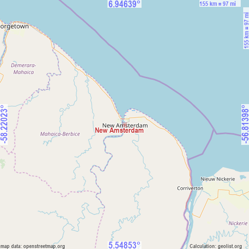
| Upper-left | 6.94639°, | -58.22023° |
| Center: | 6.24793°, | -57.5171° |
| Lower-right: | 5.54853°, | -56.81398° |
| Map W x H: | 155.4×155.4 km | = 96.6×96.6mi |
| max Lat: | 8.2° ⇑71.4% North |
| New Amsterdam: | 6.24793° |
| min Lat: | ⇓28.6% South 3.38333° |
| min Long | New Amsterdam | max Long |
| -59.8° | -57.5171° | -57.13333° |
| W 92.9%⇐ | ⇒7.1% E |
Elevation
Elevation of New Amsterdam is 7 m = 23 ft, and this is 8.3 m = 27 ft below average elevation for this country.
| Max E: |
85 m = 279 ft | 28.6% |
| Avg. | 15.3 m = 50 ft | |
| New Amsterdam | 7 m = 23 ft | |
Min E: |
0 m = 0 ft | 71.4% |
See also: Guyana elevation on elevation.city.
Geographical zone
New Amsterdam is located in North Torrid zone (between Equator and Tropic of Cancer). Distance of Equator is 694.7 km =431.7 mi to South.| Distance of | km | miles | from New Amsterdam |
|---|---|---|---|
| North Pole | 9312.4 | 5786.5 | to North |
| Arctic Circle | 6706.5 | 4167.2 | to North |
| Tropic Cancer | 1911.2 | 1187.6 | to North |
| Equator | 694.7 | 431.7 | to South |


Nearby cities:
14 places around New Amsterdam: (largest is in red/bold)
• Anna Regina
157.3 km =97.7 mi,  315°
315°
• Bartica
123.4 km =76.7 mi,  278°
278°
• Fort Wellington
18.6 km =11.6 mi,  328°
328°
• Georgetown
93.8 km =58.3 mi,  311°
311°
• Lethem
406.7 km =252.7 mi,  218°
218°
• Linden
91.3 km =56.7 mi,  253°
253°
• Mabaruma
331.1 km =205.7 mi, 310°
• Mahaica Village
66 km =41 mi, 317°
• Mahaicony Village
48.4 km =30.1 mi, 318°
• Mahdia
211 km =131.1 mi,  238°
238°
• Parika
120.2 km =74.7 mi,  303°
303°
• Rosignol
3.4 km =2.1 mi, 319°
• Skeldon
58.7 km =36.5 mi,  133°
133°
• Vreed-en-Hoop
97.7 km =60.7 mi, 309°
Sources, notices
• [Note1] Compared only with cities in Guyana existing in our database
• [Src1] Map data: © OpenStreetMap contributors (CC-BY-SA)
• [Src2] Other city data from geonames.org with taken over terms of usage.
• [Src3] Geographical zone / Annual Mean Temperature by Robert A. Rohde @ Wikipedia
