Georgetown geodata
Georgetown (Demerara-Mahaica) is a capital of a political entity; located in Guyana in America/Guyana (GMT-4) time zone. With population of 235,017 people, there are 0 cities with bigger population in this country. Compared to other cities in Guyana, 71.4% of cities are located further ↓South; 57.1% of cities are located further ←West and 85.7% of cities have higher elevation than Georgetown. Note1


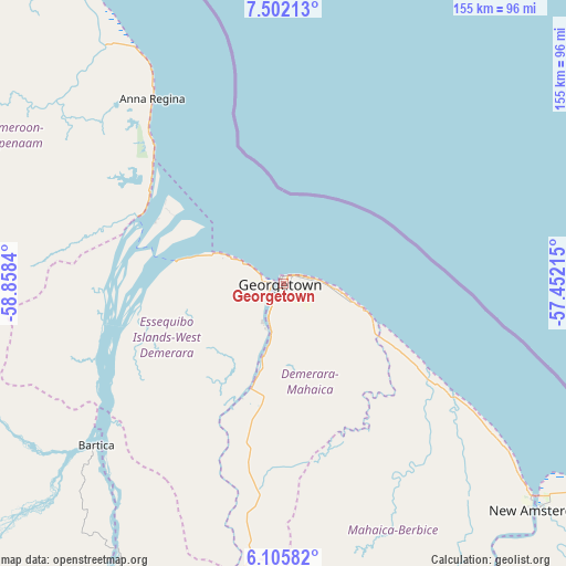
Georgetown GPS coordinates[2]
6° 48' 16.128" North, 58° 9' 18.972" West
| Map corner | latitude | longitude |
|---|---|---|
| Upper-left | 7.50213°, | -58.8584° |
| Center: | 6.80448°, | -58.15527° |
| Lower-right: | 6.10582°, | -57.45215° |
| Map W x H: | 155.3×155.3 km | = 96.5×96.5mi |
| max Lat: | 8.2° ⇑28.6% North |
| Georgetown: | 6.80448° |
| min Lat: | ⇓71.4% South 3.38333° |
| min Long | Georgetown | max Long |
| -59.8° | -58.15527° | -57.13333° |
| W 57.1%⇐ | ⇒42.9% E |
Elevation
Elevation of Georgetown is 3 m = 10 ft, and this is 12.3 m = 40 ft below average elevation for this country.
| Max E: |
85 m = 279 ft | 85.7% |
| Avg. | 15.3 m = 50 ft | |
| Georgetown | 3 m = 10 ft | |
Min E: |
0 m = 0 ft | 14.3% |
See also: Georgetown elevation on elevation.city.
Geographical zone
Georgetown is located in North Torrid zone (between Equator and Tropic of Cancer). Distance of Equator is 756.6 km =470.1 mi to South.| Distance of | km | miles | from Georgetown |
|---|---|---|---|
| North Pole | 9250.5 | 5748 | to North |
| Arctic Circle | 6644.6 | 4128.8 | to North |
| Tropic Cancer | 1849.3 | 1149.1 | to North |
| Equator | 756.6 | 470.1 | to South |


Nearby cities:
14 places around Georgetown: (largest is in red/bold)
• Anna Regina
64.2 km =39.9 mi,  322°
322°
• Bartica
67.8 km =42.1 mi,  229°
229°
• Fort Wellington
76.3 km =47.4 mi,  127°
127°
• Lethem
421.7 km =262 mi,  205°
205°
• Linden
90.1 km =56 mi,  190°
190°
• Mabaruma
237.2 km =147.4 mi,  310°
310°
• Mahaica Village
29 km =18 mi,  117°
117°
• Mahaicony Village
46.3 km =28.8 mi, 123°
• Mahdia
203.3 km =126.3 mi, 212°
• New Amsterdam
93.8 km =58.3 mi, 131°
• Parika
30.5 km =19 mi,  276°
276°
• Rosignol
90.5 km =56.2 mi, 130°
• Skeldon
152.5 km =94.8 mi, 132°
• Vreed-en-Hoop
4.7 km =2.9 mi, 276°
Sources, notices
• [Note1] Compared only with cities in Guyana existing in our database
• [Src1] Map data: © OpenStreetMap contributors (CC-BY-SA)
• [Src2] Other city data from geonames.org with taken over terms of usage.
• [Src3] Geographical zone / Annual Mean Temperature by Robert A. Rohde @ Wikipedia
