Vreed-en-Hoop geodata
Vreed-en-Hoop (Essequibo Islands-West Demerara) is a seat of a first-order administrative division; located in Guyana in America/Guyana (GMT-4) time zone. With population of 3,073 people, there are 10 cities with bigger population in this country. Compared to other cities in Guyana, 78.6% of cities are located further ↓South; 50% of cities are located further ←West and 85.7% of cities have higher elevation than Vreed-en-Hoop. Note1


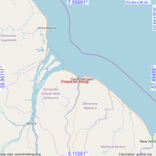
Vreed-en-Hoop GPS coordinates[2]
6° 48' 33.372" North, 58° 11' 52.728" West
| Map corner | latitude | longitude |
|---|---|---|
| Upper-left | 7.50691°, | -58.90111° |
| Center: | 6.80927°, | -58.19798° |
| Lower-right: | 6.11061°, | -57.49486° |
| Map W x H: | 155.3×155.3 km | = 96.5×96.5mi |
| max Lat: | 8.2° ⇑21.4% North |
| Vreed-en-Hoop: | 6.80927° |
| min Lat: | ⇓78.6% South 3.38333° |
| min Long | Vreed-en-Hoop | max Long |
| -59.8° | -58.19798° | -57.13333° |
| W 50%⇐ | ⇒50% E |
Elevation
Elevation of Vreed-en-Hoop is 3 m = 10 ft, and this is 12.3 m = 40 ft below average elevation for this country.
| Max E: |
85 m = 279 ft | 85.7% |
| Avg. | 15.3 m = 50 ft | |
| Vreed-en-Hoop | 3 m = 10 ft | |
Min E: |
0 m = 0 ft | 14.3% |
See also: Guyana elevation on elevation.city.
Geographical zone
Vreed-en-Hoop is located in North Torrid zone (between Equator and Tropic of Cancer). Distance of Equator is 757.1 km =470.4 mi to South.| Distance of | km | miles | from Vreed-en-Hoop |
|---|---|---|---|
| North Pole | 9249.9 | 5747.6 | to North |
| Arctic Circle | 6644.1 | 4128.5 | to North |
| Tropic Cancer | 1848.8 | 1148.8 | to North |
| Equator | 757.1 | 470.4 | to South |


Nearby cities:
14 places around Vreed-en-Hoop: (largest is in red/bold)
• Anna Regina
61.1 km =38 mi,  325°
325°
• Bartica
64.7 km =40.2 mi,  226°
226°
• Fort Wellington
80.4 km =50 mi,  125°
125°
• Georgetown
4.7 km =2.9 mi,  96°
96°
• Lethem
420.2 km =261.1 mi,  204°
204°
• Linden
89.9 km =55.9 mi,  187°
187°
• Mabaruma
233.4 km =145 mi,  311°
311°
• Mahaica Village
33.5 km =20.8 mi,  114°
114°
• Mahaicony Village
50.6 km =31.4 mi,  120°
120°
• Mahdia
201.2 km =125 mi,  211°
211°
• New Amsterdam
97.7 km =60.7 mi, 129°
• Parika
25.7 km =16 mi,  276°
276°
• Rosignol
94.4 km =58.7 mi, 129°
• Skeldon
156.3 km =97.1 mi, 131°
Sources, notices
• [Note1] Compared only with cities in Guyana existing in our database
• [Src1] Map data: © OpenStreetMap contributors (CC-BY-SA)
• [Src2] Other city data from geonames.org with taken over terms of usage.
• [Src3] Geographical zone / Annual Mean Temperature by Robert A. Rohde @ Wikipedia
