Mahaicony Village geodata
Mahaicony Village (Mahaica-Berbice) is a populated place; located in Guyana in America/Guyana (GMT-4) time zone. With population of 2,130 people, there are 11 cities with bigger population in this country. Compared to other cities in Guyana, 57.1% of cities are located further ↓South; 71.4% of cities are located further ←West and 57.1% of cities have higher elevation than Mahaicony Village. Note1


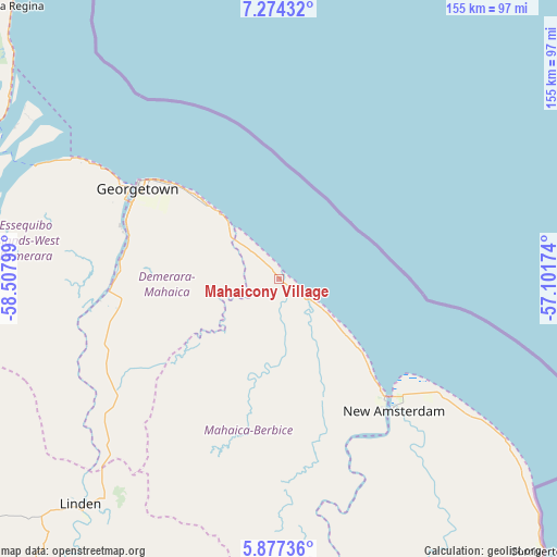
Mahaicony Village GPS coordinates[2]
6° 34' 34.788" North, 57° 48' 17.496" West
| Map corner | latitude | longitude |
|---|---|---|
| Upper-left | 7.27432°, | -58.50799° |
| Center: | 6.57633°, | -57.80486° |
| Lower-right: | 5.87736°, | -57.10174° |
| Map W x H: | 155.3×155.3 km | = 96.5×96.5mi |
| max Lat: | 8.2° ⇑42.9% North |
| Mahaicony Village: | 6.57633° |
| min Lat: | ⇓57.1% South 3.38333° |
| min Long | Mahaicony Villa | max Long |
| -59.8° | -57.80486° | -57.13333° |
| W 71.4%⇐ | ⇒28.6% E |
Elevation
Elevation of Mahaicony Village is 4 m = 13 ft, and this is 11.3 m = 37 ft below average elevation for this country.
| Max E: |
85 m = 279 ft | 57.1% |
| Avg. | 15.3 m = 50 ft | |
| Mahaicony Village | 4 m = 13 ft | |
Min E: |
0 m = 0 ft | 42.9% |
See also: Guyana elevation on elevation.city.
Geographical zone
Mahaicony Village is located in North Torrid zone (between Equator and Tropic of Cancer). Distance of Equator is 731.2 km =454.3 mi to South.| Distance of | km | miles | from Mahaicony Village |
|---|---|---|---|
| North Pole | 9275.8 | 5763.7 | to North |
| Arctic Circle | 6670 | 4144.5 | to North |
| Tropic Cancer | 1874.7 | 1164.9 | to North |
| Equator | 731.2 | 454.3 | to South |


Nearby cities:
14 places around Mahaicony Village: (largest is in red/bold)
• Anna Regina
109 km =67.7 mi,  314°
314°
• Bartica
92.2 km =57.3 mi,  258°
258°
• Fort Wellington
30.3 km =18.8 mi,  132°
132°
• Georgetown
46.3 km =28.8 mi,  303°
303°
• Lethem
418.2 km =259.9 mi,  211°
211°
• Linden
84.1 km =52.3 mi,  221°
221°
• Mabaruma
283.2 km =176 mi, 309°
• Mahaica Village
17.6 km =10.9 mi, 312°
• Mahdia
208.2 km =129.4 mi,  225°
225°
• New Amsterdam
48.4 km =30.1 mi,  138°
138°
• Parika
74.8 km =46.5 mi,  292°
292°
• Rosignol
45 km =28 mi, 138°
• Skeldon
107 km =66.5 mi, 136°
• Vreed-en-Hoop
50.6 km =31.4 mi, 300°
Sources, notices
• [Note1] Compared only with cities in Guyana existing in our database
• [Src1] Map data: © OpenStreetMap contributors (CC-BY-SA)
• [Src2] Other city data from geonames.org with taken over terms of usage.
• [Src3] Geographical zone / Annual Mean Temperature by Robert A. Rohde @ Wikipedia
