Linden geodata
Linden (Upper Demerara-Berbice) is a seat of a first-order administrative division; located in Guyana in America/Guyana (GMT-4) time zone. With population of 44,690 people, there is 1 city with bigger population in this country. Compared to other cities in Guyana, 78.6% of cities are located further ↑North; 57.1% of cities are located further →East and 57.1% of cities have higher elevation than Linden. Note1


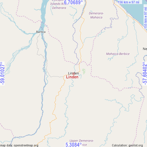
Linden GPS coordinates[2]
6° 0' 29.124" North, 58° 18' 25.704" West
| Map corner | latitude | longitude |
|---|---|---|
| Upper-left | 6.70689°, | -59.01027° |
| Center: | 6.00809°, | -58.30714° |
| Lower-right: | 5.3084°, | -57.60402° |
| Map W x H: | 155.5×155.5 km | = 96.6×96.6mi |
| max Lat: | 8.2° ⇑78.6% North |
| Linden: | 6.00809° |
| min Lat: | ⇓21.4% South 3.38333° |
| min Long | Linden | max Long |
| -59.8° | -58.30714° | -57.13333° |
| W 42.9%⇐ | ⇒57.1% E |
Elevation
Elevation of Linden is 4 m = 13 ft, and this is 11.3 m = 37 ft below average elevation for this country.
| Max E: |
85 m = 279 ft | 57.1% |
| Avg. | 15.3 m = 50 ft | |
| Linden | 4 m = 13 ft | |
Min E: |
0 m = 0 ft | 42.9% |
See also: Linden elevation on elevation.city.
Geographical zone
Linden is located in North Torrid zone (between Equator and Tropic of Cancer). Distance of Equator is 668 km =415.1 mi to South.| Distance of | km | miles | from Linden |
|---|---|---|---|
| North Pole | 9339 | 5803 | to North |
| Arctic Circle | 6733.1 | 4183.8 | to North |
| Tropic Cancer | 1937.9 | 1204.2 | to North |
| Equator | 668 | 415.1 | to South |


Nearby cities:
14 places around Linden: (largest is in red/bold)
• Anna Regina
141.4 km =87.9 mi,  350°
350°
• Bartica
56.5 km =35.1 mi,  321°
321°
• Fort Wellington
88.6 km =55.1 mi,  61°
61°
• Georgetown
90.1 km =56 mi,  10°
10°
• Lethem
335.5 km =208.5 mi,  209°
209°
• Mabaruma
293.1 km =182.1 mi,  326°
326°
• Mahaica Village
86.4 km =53.7 mi,  29°
29°
• Mahaicony Village
84.1 km =52.3 mi,  41°
41°
• Mahdia
124.5 km =77.4 mi,  228°
228°
• New Amsterdam
91.3 km =56.7 mi,  73°
73°
• Parika
93.2 km =57.9 mi, 351°
• Rosignol
90 km =55.9 mi, 71°
• Skeldon
130.6 km =81.2 mi,  96°
96°
• Vreed-en-Hoop
89.9 km =55.9 mi, 7°
Sources, notices
• [Note1] Compared only with cities in Guyana existing in our database
• [Src1] Map data: © OpenStreetMap contributors (CC-BY-SA)
• [Src2] Other city data from geonames.org with taken over terms of usage.
• [Src3] Geographical zone / Annual Mean Temperature by Robert A. Rohde @ Wikipedia
