Sentani geodata
Sentani (Papua) is a seat of a second-order administrative division; located in Indonesia in Asia/Jayapura (GMT+9) time zone. In our database, there are 407 cities with bigger population. Compared to other cities in Indonesia, 92.1% of cities are located further ↓South; 99.9% of cities are located further ←West and 50.6% of cities have higher elevation than Sentani. Note1


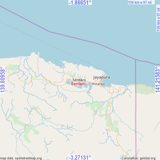
Sentani GPS coordinates[2]
2° 34' 8.76" South, 140° 30' 45.72" East
| Map corner | latitude | longitude |
|---|---|---|
| Upper-left | -1.86651°, | 139.80958° |
| Center: | -2.5691°, | 140.5127° |
| Lower-right: | -3.27131°, | 141.21583° |
| Map W x H: | 156.2×156.2 km | = 97.1×97.1mi |
| max Lat: | 5.88969° ⇑7.9% North |
| Sentani: | -2.5691° |
| min Lat: | ⇓92.1% South -10.934° |
| min Long | Sentani | max Long |
| 95.1345° | 140.5127° | 140.9419° |
| W 99.9%⇐ | ⇒0.099999999999994% E |
Elevation
Elevation of Sentani is 100 m = 328 ft, and this is 129.7 m = 426 ft below average elevation for this country.
| Max E: |
3185 m = 10449 ft | 50.6% |
| Avg. | 229.7 m = 754 ft | |
| Sentani | 100 m = 328 ft | |
Min E: |
-1 m = -3 ft | 49.4% |
See also: Indonesia elevation on elevation.city.
Geographical zone
Sentani is located in South Torrid zone (between Equator and Tropic of Capricorn). Distance of Equator is 285.7 km =177.5 mi to North.| Distance of | km | miles | from Sentani |
|---|---|---|---|
| Equator | 285.7 | 177.5 | to North |
| Tropic Capricorn | 2320.3 | 1441.8 | to South |
| Antarctic Circle | 7115.5 | 4421.4 | to South |
| South Pole | 9721.4 | 6040.6 | to South |


Nearby cities:
15 places around Sentani: (largest is in red/bold)
• Abepura
13.6 km =8.5 mi,  102°
102°
• Armopa
100.9 km =62.7 mi,  284°
284°
• Arso
46.5 km =28.9 mi,  142°
142°
• Banda
82.9 km =51.5 mi, 144°
• Betaf
148.8 km =92.5 mi,  289°
289°
• Demta
46.8 km =29.1 mi,  299°
299°
• Depapre
18.2 km =11.3 mi, 300°
• Elelim
159.7 km =99.2 mi,  214°
214°
• Genyem
40.4 km =25.1 mi,  268°
268°
• Guay
78.4 km =48.7 mi, 275°
• Jayapura
23.2 km =14.4 mi,  80°
80°
• Sawoi
20.6 km =12.8 mi,  252°
252°
• Sengge
101.9 km =63.3 mi,  163°
163°
• Ubrub
133.6 km =83 mi, 162°
• Waris
73.5 km =45.7 mi,  145°
145°
Sources, notices
• [Note1] Compared only with cities in Indonesia existing in our database
• [Src1] Map data: © OpenStreetMap contributors (CC-BY-SA)
• [Src2] Other city data from geonames.org with taken over terms of usage.
• [Src3] Geographical zone / Annual Mean Temperature by Robert A. Rohde @ Wikipedia
